
Getting Here
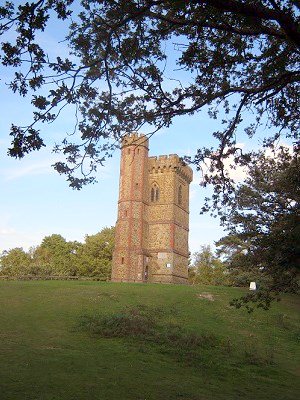
Leith Hill is an iconic high spot in the Surrey Hills National Landscape with sweeping views towards London to the north and the English channel to the south and an eighteenth-century tower.
By Road
- Windy Gap Car Park: Abinger Road, RH5 6HG
- Broadmoor Car Park: Wotton, RH5 6JY
- Starveall Car Park: Leith Hill Road, RH5 6LX
- Friday Street Car Park: Dorking, RH5 6JR
- All car parks are free
- These car park has unmarked car parking spaces
- If visiting with tall vehicles, please be aware our car parks have a height barrier. Max Height 1.9m – 6’2”
- Please note both Landslip and Rhododendron Wood car parks are managed by the National Trust
By Public Transport
- Nearest Train Station is Holmwood
- Bus Provider and bus stop: Metrobus service 22, Friday Street on Hollow Lane
- Surrey Connect Bus Service to Windy Gap, Broadmoor, Starveall and Friday Street car parks
Surrey Connect is the ideal way to access Surrey’s countryside. This convenient on-demand bus service is available to all, making Surrey’s countryside more accessible for those without access to a car or who want to choose a more sustainable option.
Book your journey via the Surrey Connect app, website or by phone. Select Central South as the territory, and Windy Gap, Broadmoor, Starveall car park or Hollow Lane Friday Street as your bus stop.
By Bicycle
- Cyclists are permitted on this site, but must only use bridleways or byways that run through the site
- For directions, please use the map below
- There is access from this site onto the Leith Hill Greenway, a 9 mile multi-user route linking Leith Hill with Box Hill. For further information, please visit Surrey Hills National Landscape website
- For details on bridleway, byway or footpath information please visit our Countryside interactive map
By Foot
- For directions, please use the map below
- For details on bridleway, byway or footpath information please visit our Countryside interactive map
Horse Riding
- Horse riders are permitted, but must use the bridleways. Where possible horse riders should keep to wider paths. Please refer to the interpretation board on site for further information
- There is no horsebox parking available at this countryside site
- For details on bridleway, byway or footpath information please visit our Countryside interactive map
Location map
On the map below, use the plus symbol to zoom in to see the locations of the site's paths and car parks and the minus symbol to zoom out to view where the site is situated in Surrey, and to see other countryside sites nearby. The home symbol resets the map to the default setting.
Things to see and do
Leith Hill has been popular with visitors since the Victorian times. There is plenty of space for family adventures with a myriad of footpaths and bridleways with picnic spots to take in the views.
Key points of interest
- Two self-guided trails; Acorn and Nightjar Trail
- Leith Hill Tower – please refer to National Trust website for opening times
- Highest point in South East England from the top of the Tower
- Viewpoint
- Greensand Way
- Leith Hill Greenway
Nature to discover
- Trees: Oak, hazel, beech, pine, birch
- Flora and fauna: Heather, gorse, bilberry
- Birds and butterflies: Nightjar, woodlark, skylark, buzzard, barn, owl, woodpecker, gold finch, gold crest and Green hairstreak, heath fritillary, grayling butterflies
- Mammals: Hazel dormouse, bats, roe deer
Always respect, protect and enjoy leaving no trace of your visit.
Facilities
- Dogs allowed. Please keep dogs under close control and on paths
- Benches are located throughout this site
- There are no general waste bins on this site, please take your litter a home with you
- A dog waste bin is located close to Starveall car park. Please dispose of your dog waste responsibly in this bin
- Kiosk, selling hot and cold drinks, available at the base of Leith Hill Tower
- Nearest toilet is available at Leith Hill Place (National Trust) and only open during house opening times. Please check the National Trust website for more information about Leith Hill Place and Leith Hill Tower
Self-guided trails
There are two self-guided routes at Leith Hill, the Acorn and Nightjar trails. Take a photo of the information board in the car park before setting off and follow the colour coded routes and signposts along the way.
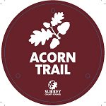 The Acorn self-guided trail - 2.6 mile, 1 hour 15 minute walk
Follow the circular Acorn trail from Starveall Corner car park through the peaceful woodland and heathland. Path uneven and steep in parts but you will be rewarded with spectacular views at the top and the opportunity to climb the steep stone spiral
staircase to the top of Leith Hill Tower - the highest point in south-east England! (please visit National Trust website for opening times of the Tower).
Follow the Acorn route on the digital Ordnance Survey (OS) map.
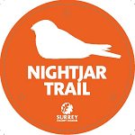 The Nightjar self-guided trail - 3.5 mile, 1 hour 45 minute walk
To navigate your way around Leith Hill we would recommend using Ordnance Survey (OS) Explorer map 146.
Follow the Nightjar route on the digital Ordnance Survey (OS) map.
Additional Information
The Greensand Way is a long-distance route that starts in Haslemere, Surrey and ends at Ham street in Kent. It follows the Greensand Ridge along the Surrey Hills and crosses Leith Hill. There is access from this site onto section 5 of the Greensand Way.
For more walking trail inspiration, please visit our Self-guided walks around Surrey webpage.
Accessibility
- There are no accessible self-guided trails at this site
- Trails to the summit and tower are inaccessible to those with limited mobility
- Steep climbs to the Tower
- All car parks have unmarked car parking spaces
- Kiosk, selling hot and cold drinks, available at the base of Leith Hill Tower
- Nearest toilet is available at Leith Hill Place (National Trust) and only open during house opening times. Please check the National Trust website for more information
Contact Us
This site is owned by the Wotton Estate with public access managed by Surrey County Council (SCC). The National Trust owns Leith Hill Tower and the land immediately around it.
To contact us, please use one of the options below:
Email: countryside.estate@surreycc.gov.uk
Phone: 03456 009 009
Send us any photos you take that you're happy to share on social media, tag @ExploreSurreyUK
Newsletter
Did you know the Countryside team have a newsletter? Countryside Matters is a seasonal newsletter that will keep you up to date on what's going on across Surrey's countryside, including what our countryside teams are working on.
Sign up to our countryside newsletter