
Quick guide and location map
A picturesque high spot set in the Surrey Hills above Abinger, with bluebells in spring and outstanding views and a variety of wildlife throughout the year. Please always follow the Countryside Code.
Quick guide
- Address and references: GU5 6SL
OS map reference: TQ113491
What3Words: linen.total.pitch - Type of site: ancient woodland, hill
- Accessibility: not accessible
- Facilities: large free car park, self-guided trails, no toilets or refreshments onsite.
- Nature to discover: birds, butterflies.
- Dogs: please keep your dog under control.
- Size: approximately 3.2 kilometres (2 miles).
Location map
On the map below, use the plus symbol to zoom in to see the locations of the site's paths and car parks and the minus symbol to zoom out to view where the site is situated in Surrey, and to see other countryside sites nearby. The home symbol resets the map to the default setting.
White Down is split into two by White Down Lane and it has many footpaths that intersect, providing a good choice of walking routes. One of the paths leads from the car park located off White Down Lane, GU5 6SL.
Site details
Description
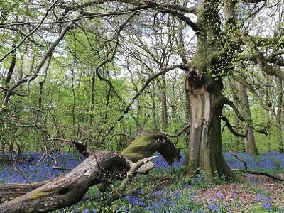
White Down is an unspoilt spot high in the hills above Abinger which can also be accessed off the road to Ranmore Common. The site is an uphill climb from the car park past many areas of undisturbed woodland which show off their beautiful annual bluebell displays. White Down is hilly and muddy after rainfall and during winter months.
Walk further on and you will come to an open area of chalk grassland and the North Downs Way National Trail. The trail runs through Blatchford and Hackhurst Downs, which is looked after by the National Trust.
There are many World War II pillboxes along this section of the hillside, with views to Surrey Hills villages below and beyond to the Greensand Ridge.
Please take care of our countryside and open spaces by following the Countryside Code.
What you can do here
- Get away from it all at this unspoilt location
- Explore this large woodland site and take a picnic
- Enjoy dog walking - under effective control
- Explore the North Downs Way long distance trail
Self-guided walks
The trail with signposts to guide you from White Down is being updated. Follow the colour coded routes on the information board and the signposts along the way.
What you can see here and when
- Great views from Blatchford and Hackhurst Downs
- Historic pillboxes on the chalk hillside
- Seasonal colour, bluebells in springtime in the woodland
- Nature to discover: a variety of birdlife, some mammals and butterflies on sunny days from April to September, including the Common Blue butterfly. Browse the Surrey Wildlife Trust Wildlife Explorer to find out more about the wildlife that can be seen in Surrey
Site management, contact and designations
Site management
We manage White Down on behalf of the Wotton Estate who own the land. We manage public access including site management and litter bins, car park and visitor services such as self-guided walking trails.
Contact
Send us any photos you take that you're happy to share on social media, tag @ExploreSurreyUK
If you need to contact us about any issues on White Down, please use one of the options below:

Environmental designations of White Down and what they mean
Surrey Hills National Landscape, an Area of Outstanding Natural Beauty (AONB) covers a quarter of the county of Surrey. The Surrey Hills AONB was created in 1958 for conservation due to its significant landscape value and enjoys levels of protection from development. Find out more about the Surrey Hills.
Ancient Woodlands are areas of persistent undisturbed woodland that have survived since 1600 in England, they are home to many species of plants, fungi and insects so of great benefit to biodiversity.