Getting Here

Chinthurst Hill is at the heart of the Surrey Hills National Landscape and lies south of Guildford between the villages of Shalford and Wonersh. Reaching a height of over 120m, it affords panoramic views towards east Surrey.
By Road
- Chinthurst Hill Car Park: Kings Road, Wonersh Common, Guildford GU5 0PR
- Free car park
- This car park has unmarked car parking spaces
- If visiting with tall vehicles, please be aware our car parks have a height barrier. Max Height 1.9m – 6’2”
By Public Transport
- Nearest train station is Shalford
- Bus provider and bus stop: Compass Travel Service 32, Rice’s Corner (at junction of New Road/ Christmas Hill)
By Bicycle
- Cyclists are permitted on this site, but must only use bridleways or byways that run through the site
- For directions, please use the map below
- There is access onto the Downs Link on this site. For further information, please visit the Cycle network website
- For details on bridleway, byway or footpath information please visit our Countryside interactive map
By Foot
- For directions, please use the map below
- For details on bridleway, byway or footpath information please visit our Countryside interactive map
Horse Riding
- Horse riders are permitted, but must use the bridleways. Where possible horse riders should keep to wider paths. Please refer to the interpretation board on site for further information
- There is no horsebox parking available at this countryside site
- For details on bridleway, byway or footpath information please visit our Countryside interactive map
Location map
On the map below, use the plus symbol to zoom in to see the locations of the site's paths and car parks and the minus symbol to zoom out to view where the site is situated in Surrey, and to see other countryside sites nearby. The home symbol resets the map to the default setting.
Visitor Information Video
Things to see and do
This beautiful Local Nature Reserve is located on a hillside. Discover over 42 acres of woodland, heathland and lowland acid grassland where you can lose yourself in nature.
Key points of interest:
- Natural play trail
- Two self-guided trails; Bluebell and Tower Trail
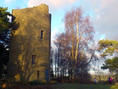
- Grade II listed stone folly at hilltop
- Impressive views at the hilltop all year round
- The Downs Link off-road route, which starts at St Martha’s Hill and finishes in Shoreham-by-Sea, goes through the base of Chinthurst Hill.
- Seasonal highlights; Spring bluebells and autumn colour
- Permanent and signed orienteering course. Visit the Guildford Orienteers website for a map of the course
Nature to discover:
- Trees: Oak, yew, hazel, common hawthorn
- Flora and fauna: Bluebells, primrose, wood anemone, yellow archangel, wild garlic (lady’s smock)
- Birds and butterflies: Sparrowhawk, nuthatch, red kite, brimstone, small blue, ringlet, orange tip and large white butterfly
- Mammals: Bats and roe deer
Always respect, protect and enjoy leaving no trace of your visit.
Facilities
- Picnic Area
- Benches located throughout this site
- Dogs allowed. Please keep dogs under close control and on paths
- A dog waste bin is located close to the car park. Please dispose of your dog waste responsibly in this bin
- There are no general waste bins on this site, please take your litter home with you
- There are no refreshments or toilets on site. The nearest café and toilets are located at The Snooty Fox Café, Shalford
Self-guided trails
There are two self-guided routes at Chinthurst Hill, the Bluebell and Tower trails. Take a photo of the information board in the car park before setting off and follow the colour coded routes and signposts along the way.
 The Bluebell self-guided trail – 1 mile, 30 minute walk
Follow the Bluebell waymarks on this gentle climb around the hill taking in views of peaceful open fields to the summit of the hill. Enjoy far reaching views on a clear day before heading back down through the shady canopy of the broadleaved woodland path to the car park. The perfect time of year to do this walk is in bluebell season (April/May), when you are rewarded with vibrant displays!
Follow the Bluebell route on the digital Ordnance Survey (OS) map.
 The Tower self-guided trail – 0.5 mile, 20 minute walk
For a more direct route to the top of the hill follow the Tower trail. A steeper climb up steps to the summit where you will discover an impressive stone folly and stunning views before returning back down the steps to the car park.
Follow the Tower route on the digital Ordnance Survey (OS) map.
Additional information:
The Downs Link route, for walkers, cyclists and horse riders, starts just below St Martha's Church, Chilworth and goes around the base of Chinthurst Hill.
For more walking trail inspiration, please visit our Self-guided walks around Surrey webpage.
Accessibility
- There is an accessible path to the picnic bench area beside the car park
- There are no accessible self-guided trails at this site. Trails to the hilltop are not suitable for wheelchairs or buggies
- The woodland path can be steep and uneven in places
- This car park has unmarked car parking spaces
- There are no refreshments or toilets on site. The nearest café and toilets are located at The Snooty Fox Café, Shalford
Contact Us

This site is owned by Surrey County Council with conservation managed by Surrey Wildlife Trust.
To contact us, please use one of the options below:
Email: countryside.estate@surreycc.gov.uk
Phone: 03456 009 009
Send us any photos you take that you're happy to share on social media, tag @ExploreSurreyUK
Newsletter
Did you know the Countryside team have a newsletter? Countryside Matters is a seasonal newsletter that will keep you up to date on what's going on across Surrey's countryside, including what our countryside teams are working on.
Sign up to our countryside newsletter

