About the walk
A 2 mile (3.5km) circular walk near Abinger from White Down car park through beautiful, tranquil woodland, with renowned springtime bluebell displays and open chalk grassland slopes that have magnificent views.

Route details
Please note: This walk follows public footpaths and bridleways which cross private and public land. Please respect people's privacy, keep dogs under control and remember the Countryside Code.
- Start/finish: White Down car park, White Down Lane RH5 6PZ
- Difficulty: Moderately challenging
- Distance: 2 miles (3.5 kilometres)
- Approximate time: about 1 hour
- Type of walk: circular
- Accessibility: no stiles, two gates and some slopes
- Facilities: No toilets on the walk but refreshments nearby at the Kingfisher farm shop and several pubs in Abinger and Gomshall
- What to see: Views from North Downs, bluebells in spring in woodland
- OS Map Explorer 146: Dorking, Box Hill and Reigate.
Description
You will see many lovely views on this walk which goes through woodland, chalk grassland, along drove roads and passes the famous WWII pillboxes that provided a line of defence from German planes. Old Simm's Copse and Dunley Wood provide a wonderful display of bluebells in the spring. You will be joining part of the North Downs Way national trail.
How to get there
Car
Free White Downs car park on White Down Lane (2 metre height restriction).
If you are coming from the south, the entrance for White Down Lane is on A25, just east of Abinger Hammer (approximate postcode RH5 6PZ). From this point follow White Down Lane north (steeply uphill) for 1.5 miles, car park is on the left.
If you are coming from the north, the entrance for White Down Lane is at the junction between Ranmore Common Road and Crocknorth Road (approximate postcode RH5 6SL). From this point follow White Down Lane south for half a mile to the car park on the right.
Bus
There is no public transport available for this walk.
Walk directions
The numbers of each stage of the walk correspond with the points shown on the map. Follow the Acorn trail signposts along the whole route.
Stages of the route
- Start to Old Simms junction
- Stage 1: Old Simms junction to North Downs Way
- Stage 2: North Downs Way to White Down Lease Gate
- Stage 3: White Down Lease Gate to car park
Start to Old Simms junction
Walk to the top of car park away from road where you will find a vehicle barrier. On right you will also see a signpost with for the self-guided trail that your walk will be following for its entire length. Pass alongside vehicle barrier and keep directly ahead heading steadily uphill on the bridleway, which is an old drove road. On your right you will see a bank running alongside path, topped with a line of beautiful old twisted beech trees. As the path levels off you will come to a signpost marking a crossroads. Keep straight ahead and stay with this main path first meandering ahead and later, bearing left. On the right is Old Simm's Copse, known as Bluebell Woods by locals, for good reason as you'll discover if you visit in the spring. Eventually the path leads to a staggered crossroads marked with a signpost.
Stage 1: Old Simms junction to North Downs Way
Turn right and follow wide bridleway with copse still on your right. Further along, the path winds through section of heavily coppiced trees to reach next signpost marking a junction with another bridleway. Turn left and follow stone track as it goes downhill. This is an old coach road. After just a short distance you will come to a clearing between two lines of fencing and a signpost, marking the junction with North Downs Way (NDW). Turn left, passing through a kissing gate to enter the National Trust (NT) site of Blatchford Downs.
Stage 2: North Downs Way to White Down Lease Gate
Follow the grass path leading you steadily downhill and passing a couple of handy benches on left, ideal spot for enjoying views across the chalk grassland slopes and the valley beyond. This special chalk grassland habitat was created by grazing animals in the past, allowing the grassland to establish and many species of plants and butterflies to thrive.
The path swings left, entering a small belt of trees. Within woodland on left you will see remains of a brick pillbox. Most of the North Downs pillboxes still remain and today make important roosts for bats. Simply continue ahead on NDW, passing a second pillbox on your right, a third on your left and then a fourth across to your right once again. Eventually, you will come to a kissing gate alongside a National Trust sign for White Down Lease.
Stage 3: White Down Lease Gate to car park
Pass through this gate and a few paces later you will come to a signpost, marking a staggered crossroads. Turn sharp left here, to join signed public footpath leading you steeply uphill and soon following a line of wire fence on your left. Stay with path as it swings left and levels off, still following fence line on your left. As you pass a large yew tree on your left, stay with path which veers right heading away from fence, passing a signpost and leading you uphill once again. A little way up, path swings left to merge with a wider track. 30 metres later, you will see a signpost on your right. Turn right, leaving main track to join a narrow path which winds through a short section of trees to reach a staggered crossroads (which you may recognise from the outward leg).
Turn right here and follow this track as it swings steadily left, leading you through Dunley Wood, privately owned by the Wotton Estate, comprising a variety of trees including oak, ash, cherry, beech, larch and pine and also a thriving bluebell population. Further along, the path leads you past green railings and grass mounds of a water reservoir on your right, owned by the East Surrey Water Company. Immediately after reservoir you will reach a staggered crossroads, stay on main track. About 30 metres later as you reach a signpost, turn left to join narrower stone path winding through trees. You will emerge to the crossroads of paths that you passed through at start of walk.
Turn right to join bridleway and this will lead you directly back to car park where your walk began.
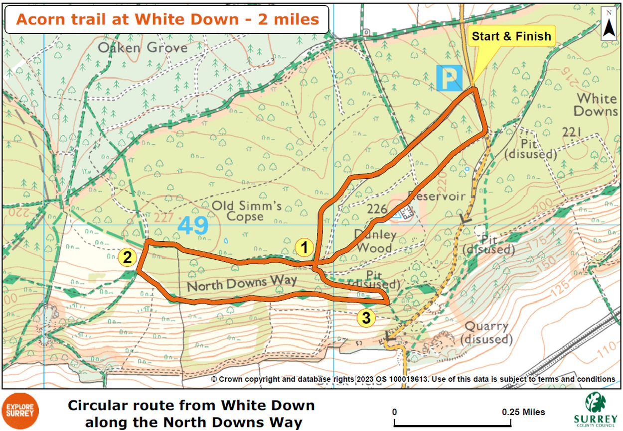
Map
Map shows the 2 mile route from its start and finish points at White Down free car park. It goes through woodland of Old Simm's Copse, joins the North Downs Way trail at Blatchford Down (owned by the National Trust), passes through Dunley Wood, before retracing back to the car park. Select the map of the route below to open a larger version in a new window, that can be printed, if necessary, using your browser print tool with landscape selected. Alternatively, you can save the image to your mobile device, for reference on your walk.