Page Contents
About the walk
- Start address: Deepdene End, Dorking, RH5 4BG (approximate postcode)
- Distance: 6 miles
- Approximate time: 3 hours
- Grid references: Deepdene, Dorking TQ175491, end of section at Reigate Park TQ247494
- OS Explorer Map: 146
Walk directions
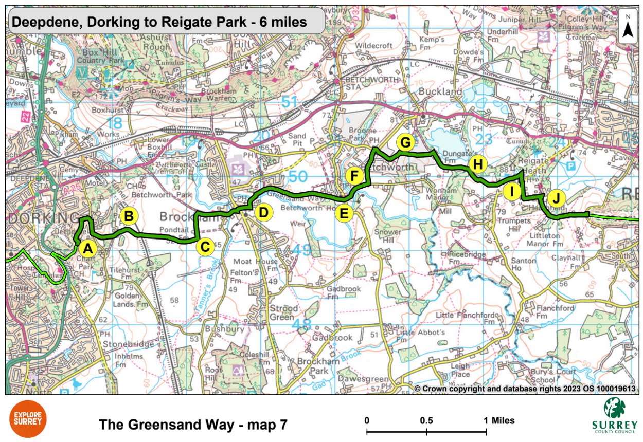
The following letters correspond with the route directions on the map.
A. Turn left onto a metalled track by Deepdene End. Turn right at the T-junction, then right again along Punchbowl Lane. Turn left onto the driveway to Park Farm.
B. Go ahead to pass farm buildings. Go under the railway bridge and continue beside the old hedgerow. At the end of the field turn right, then immediately left and cross a stile. Go ahead along the field edge and through a stile/gate, then continue to the next field corner. Cross the stile. Turn left to another stile by Pondtail Farm.
C. Cross a farm road, then continue ahead over three stiles. Turn right along a farm track. Turn left at the end along the road to Brockham village green. Cross the green and continue passing the Royal Oak pub and the Grumpy Mole pub. Continue to a wooden gate at the end of the road.
D. Turn left along a metalled path. Cross the bridge over the River Mole and keep right along the lane above the river. Turn right to pass behind houses and cross a bridge. Continue ahead beside fields for 770 yards. Go ahead through gates beside a farm. Cross a driveway and take the path through the churchyard to the right of the Church of St Michael and All Angels, Betchworth. Go through the stone gateway and ahead past Forge Cottage.
E. Cross the road with the Dolphin Inn on your left and go ahead along Wonham Lane. Walk for 200 yards and then climb steps on the left to join a path above the road. Continue parallel with the road, then turn left into a field and follow the hedge on your right to the near righthand corner of the field.
F. Turn left along Sandy Lane and walk up to a T-junction. Turn right, then in 25 yards, turn right again, up steep steps and continue to go through kissing gate and continue ahead. After 165 yards, cross a stile and walk left across the field to a gate and stile in the far left-hand corner. Cross the stile then turn right and almost immediately go through the kissing gate on the far side of the lane.
G. Go ahead with the hedge on your left, to a metal kissing gate. Continue ahead, with first a hedge and then a fence on your right, to another kissing gate and follow a small path to the road. Turn right down a farm lane (Dungates Lane). Turn left through Dungate's farmyard with farm buildings either side. Walk for one quarter mile to a Y-junction.
H. Turn right through a double gate and follow a broad track diagonally across a field. Ignoring a gate on your right, continue through a wooden gate until you arrive at a cottage. Go ahead at a cross track to follow the path across a golf course fairway up towards the windmill on Reigate Heath. Keep to the right of the windmill and clubhouse and walk along a track through the golf club's car park.
I. 20 yards before the track turns sharp left, turn right (not sharp right) down a footpath. Cross a road and a fairway and follow the metalled track past The White House. At Bracken House keep right uphill into woodland, passing Ivy Cottage and Tile House on the left. Go ahead down a narrow track. Continue past the front of the Skimmington Castle pub and walk down the slope ahead to a cross bridleway.
J. Turn right along the bridleway to reach a lane. Keep left along the lane that climbs uphill to a road. Cross the road and go up steps. At the top of the steps turn left steeply uphill, ignoring paths to right then left until the path flattens out and you are in Reigate Priory Park, which is near the centre of Reigate town.
What to see
Betchworth Park: In the Middle Ages a castle stood beside the River Mole, to the north of Betchworth Park. The park was later renowned for its chestnuts and its elm avenues.
Quarries: Chalk pits and lime works produced hearthstone and firestone as well as lime for agricultural use. The works were known for the Brockham Continuous Lime Kiln patented there in 1889. Bricks were produced into the 20th century.
River Mole: Some say the river takes its name from the animal since, on occasions during drought, it flows underground between Dorking and Leatherhead. Others claim that the Latin Mola for Mill is more apt in view of the many watermills the river powered.
Reigate Heath: Long barrows on the north of the Heath reveal a Neolithic burial site. Settlers in the region may have traded between Stonehenge and the Low Countries.
Reigate Heath Mill: A post mill was built here around 1765. The mill ceased working in about 1870 and was converted to a chapel of ease to St Mary's Parish Church, Reigate in 1880. It is the only consecrated windmill in the country.
Map 7
Map seven starts at Deepdene, Dorking continuing broadly parallel and south of the A25. It passes Brockham and Betchworth, on through farmland until it reaches Reigate Heath golf club and the windmill. It continues on past the Skimmington Castle pub, crossing the road and on into Reigate Priory Park, where this section ends. Select the map of the route below to open a larger version in a new window, that can be printed, if necessary, using your browser print tool with landscape selected. Alternatively, you can save the image to your mobile device, for reference on your walk.