
Getting Here
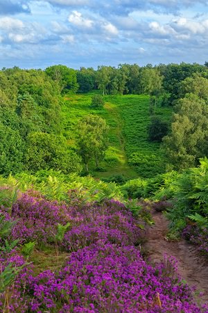
This extensive common, within the Surrey Hills National Landscape, forms part of the Wealden Heaths National Nature Reserve (NNR) and is abundant with wildlife, flora, fauna and pond life. Enjoy far reaching views and colourful carpets of heather in late summer.
By Road
- Top Car Park: Suffield Lane, GU3 1BG
- Middle Car Park: Suffield Lane, GU3 1BQ
- Britty Wood Car Park: Littleworth Road, GU10 1JJ
- Tarn Car Park: Littleworth Road, GU10 1JH
- Totford Car Park: Totford Lane, GU3 1BQ
- All car parks are free
- These car parks has unmarked car parking spaces
- If visiting with tall vehicles, please be aware our car parks have a height barrier. Max Height 1.9m – 6’2”
By Public Transport:
- Nearest Train Station is Farnham
- There are no public buses to Puttenham Common
- Surrey Connect Bus Service to Top, Middle, Britty Wood, Tarn and Totford Hatch car parks
Surrey Connect is the ideal way to access Surrey’s countryside. This convenient on-demand bus service is available to all, making Surrey’s countryside more accessible for those without access to a car or who want to choose a more sustainable option.
Book your journey via the Surrey Connect app, website or by phone. Select Southwest Farnham as the territory, and either Puttenham Common, Britty Wood, Puttenham Tarn car park or Totford Lane Farnham as your bus stop.
By Bicycle:
- Cyclists are permitted on this site, but must only use bridleways or byways that run through the site
- For directions, please use the map below
- Cycle Surrey Hills is a network of over 50 miles of off-road cycling trails in south-west Surrey. The Puttenham and Elstead loops cross Puttenham Common. Route details can be found on the Surrey Hills National Landscape website
- There is access from this site onto the North Downs Way National Trail, a 153 mile multi-user route between Surrey and Kent. For further information, please visit the National Trails website
- For details on bridleway, byway or footpath information please visit our Countryside interactive map
By Foot
- For directions, please use the map below
- For details on bridleway, byway or footpath information please visit our Countryside interactive map
Horse Riding
- Horse riders are permitted, but must use the bridleways. Where possible horse riders should keep to wider paths. Please refer to the interpretation board on site for further information
- There is no horsebox parking available at this countryside site
- For details on bridleway, byway or footpath information please visit our Countryside interactive map
Location map
On the map below, use the plus symbol to zoom in to see the locations of the site's paths and car parks and the minus symbol to zoom out to view where the site is situated in Surrey, and to see other countryside sites nearby. The home symbol resets the map to the default setting.
Things to see and do
Large areas of heathland, grassland, woodland and large ponds combine to provide extensive public open space ideal for exploring by foot, bike or horse!
Key points of interest:
- Three self-guided trails; Woodlark, Bell Heather and Butterfly trails
- Seasonal highlights; Summer heather and autumn colour
- Ponds
- Highbury Hill fort
- Viewpoints
- North Downs Way
- Waggoners campsite
- Cattle grazing to help conservation
Nature to discover:
- Trees: Birch, oak, scots pine, willow, alder
- Flora and fauna: Bracken, fly agaric, heather varieties
- Birds and butterflies: Skylark, woodlark, green woodpecker, dartford warbler, stonechat, nightjar, nightingale, red kites, buzzards and Silver-studded blue, grayling, heath fritillary butterfly
- Reptiles and insects: Adder, sand lizard, slow worm, dragonfly
Always respect, protect and enjoy leaving no trace of your visit.
Always be wildfire aware on heathland. No BBQs or litter.
Facilities
- Picnic Area
- Benches are located throughout this site
- Dogs allowed. During ground nesting bird season (1 March to 15 September) keep dogs under close control and on paths. We recommend putting dogs on leads around livestock
- General waste bins are located at Top Car Park. Please dispose of your litter and dog waste responsibly in these waste bins.
- Refreshments can be found at Top Car Park with the mobile caterer, Little Coffee Pantry. Open Thursday to Sunday. Please refer to Little Coffee Pantry facebook page for opening times
- There are no toilets on site. The nearest toilets are located at The Good Intent Pub or The Cyder House Inn Pub
Self-guided trails
There are three self-guided routes on Puttenham Common, the Woodlark, Bell Heather and Butterfly trails. Take a photo of the information board in the car park before setting off and follow the colour coded routes and signposts along the way.
 The Woodlark self-guided trail - 3.5 mile, 2 hour 30 minute walk
Follow the Woodlark trail waymarks from either Top or Totford Hatch car park. Head through woodland and around the heath on a circular trail passing ponds, and enjoy splendid views at many points.
Follow the Woodlark route on the digital Ordnance Survey (OS) map.
 The Bell Heather self-guided trail - 1.5 mile, 1 hour walk
Follow the Bell Heather trail waymarks from Top car park up to the ancient Hillbury hill fort along sandy paths with no gates or stiles. Enjoy wonderful, far reaching views along the way.
Follow the Bell Heather route on the digital Ordnance Survey (OS) map.
 The Butterfly self-guided trail - 1 mile, 45 minute walk
Follow the Butterfly trail waymarks from Middle car park along sandy paths and through peaceful woodland with some inclines. A delightful short walk taking in the beauty of the common.
Follow the Butterfly route on the digital Ordnance Survey (OS) map.
Additional Information
The North Downs Way, a National Trail starting in Farnham, Surrey and finishing 153 miles later in Dover, Kent runs right through Puttenham Common.
For more walking trail inspiration, please visit our Self-guided walks around Surrey webpage.
Accessibility
- There are no accessible self-guided trails at this site
- The paths can be steep, uneven and sandy in places
- All car parks have unmarked car parking spaces
- Refreshments can be found at Top Car Park with the mobile caterer, Little Coffee Pantry. Open Thursday to Sunday. Please refer to Little Coffee Pantry facebook page for opening times
- There are no toilets on site. The nearest toilets are located at The Good Intent Pub or The Cyder House Inn Pub
- The nearest accessible trail is located at Royal Common easy access trail near Elstead village.
Contact Us
Puttenham Common is owned by the Hampton Estate with public access managed by Surrey County Council.
To contact us, please use one of the options below:
Email: countryside.estate@surreycc.gov.uk
Phone: 03456 009 009
Send us any photos you take that you're happy to share on social media, tag @ExploreSurreyUK
Newsletter
Did you know the Countryside team have a newsletter? Countryside Matters is a seasonal newsletter that will keep you up to date on what's going on across Surrey's countryside, including what our countryside teams are working on.
Sign up to countryside matters newsletter