Quick guide and location map
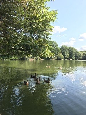
These nine commons around Worplesdon, near Guildford offer lovely walks, pretty wildflower meadows and heathland, as well as Britten's Pond that attracts lots of wildlife. Please always follow the Countryside Code.
Quick guide
- Address and references: Saltbox Road, Guildford GU3 3LH
Ordnance Survey (OS) map reference: SU982529
What3Words: racing.overnight.shaky - Type of site: Local Nature Reserve, heathland and woodland
- Accessibility: accessible boardwalk around Britten's Pond
- Facilities: picnic areas with some benches, three free car parks
- Nature to discover: birds, dragonflies, butterflies and deer
- Dogs: please keep your dog under control
- Size: 183 hectares (452 acres)
Location map
On the map below, use the plus symbol to zoom in to see the locations of the site's paths and car parks and the minus symbol to zoom out to view where the site is situated in Surrey, and to see other countryside sites nearby. The home symbol resets the map to the default setting.
The nine commons have three car parks. Whitmoor Common on Saltbox Road, GU3 3LH and Britten's Pond on Saltbox Road, GU4 7PX and there is also the Burdenshott Road car park near the Jolly Farmer pub, GU3 3RN.
Visitor Information Video
Site details
Description
The Worplesdon Group of Commons is made up of nine commons within the parish of Worplesdon near Guildford, some of them are inter-linking. They are:
- Whitmoor and Rickford Commons (Saltbox Road car park)
- Gooserye Common (near Saltbox Road car park)
- Stringers Common including Britten's Pond (Britten's Pond car park, Saltbox Road)
- Chitty's Common, Stoughton
- Rydes Hill, Stoughton
- Broad Street, Wood Street village
- Clasford Common, Wood Street village
- Littlefield Common, Worplesdon
These commons provide valuable green space on the north side of Guildford's urban centre where you'll find heathland, woodland and various ponds to get away from it all. They were originally grazing lands for commoners, with the ponds created for grazing stock to drink from, they are now an abundant haven for wildlife and wildflower meadows. Pay a visit to these commons at any time of year and you'll always find something natural to experience.
Access to Britten's Pond is from Salt Box Road where there is a level flat trail around the pond with many benches and a wheelchair-accessible viewing platform. Guildford Angling Society have fishing rights on Britten's Pond, helping to keep the ponds in good condition for wildlife.
Please take care of our countryside and open spaces, particularly heathland areas where fire risk is a constant threat, and follow the Countryside Code.
What you can do here
- Discover pond life
- Access the natural environment
- Get away from it all
- Varied walking self-guided trails
- Outdoor education
- Family natural play and picnics
- Dog walking - under effective control
Self-guided walks
There are four walking routes for different abilities on the group of commons. Follow the colour coded routes on the information boards in each car park and the signposts along the way.
The 2.7 mile Nightjar Trail from Salt Box Road car park. Meander through mixed woodland and heathland with a gradual uphill climb with distant views of the North Downs and Guildford Cathedral.
The 2 mile Dragonfly Trail from the Salt Box Road car park, through heathland to the largest pond on the common. A mostly flat path but it can be uneven in places.
The 1 mile Acorn easy access Trail from the Salt Box Road car park. This short walk has sandy pathways which can be narrow in places, no barriers or stiles.
The 650 metre Newt Trail from the Britten's Pond car park. This level route takes you around Britten's Pond with some of the pathways on a boardwalk. The route can be uneven in places but is accessible for all.
There are two routes available from AllTrails.com :
What you can see here and when
- Spring: bright yellow celandines along the banks of the stream.
- Late summer and autumn: heathland flowers.
- Nature to discover: many species of bird spotted around the pond, plus emperor dragonflies, butterflies, including silver-studded blue in summer and mammals such as bats and roe deer. For more information about the wildlife to look out for visit the following Surrey Wildlife Trust pages:
Accessibility
There is a path and viewing platform around Britten's Pond that is accessible for wheelchairs or buggies although it can be muddy after heavy rainfall, find out more Britten's Pond easy access trail.
Car park location
There are three car parks.
- Whitmoor Common on Saltbox Road, GU3 3LH
- Britten's Pond on Saltbox Road, GU4 7PX
- Burdenshott Road car park near the Jolly Farmer pub, GU3 3RN
Self-guided trails
There are four self-guided trails at Worplesdon Commons, the Nightjar, Dragonfly, Acorn and Newt trails. Take a photo of the information board in the car park before setting off and follow the colour coded routes and signposts along the way.
 The Nightjar self-guided trail - 2.7 mile, 1 hour 30 minute walk
Follow the Nightjar trail from Salt Box Road car park. Meander through mixed woodland and heathland with a gradual uphill climb with distant views of the North Downs and Guildford Cathedral. If you head out at dusk during the early summer months you may be lucky enough to hear the gentle 'churr' sound of a nightjar!
 The Dragonfly self-guided trail - 2 mile, 1 hour walk
Follow the Dragonfly trail from the Salt Box Road car park, through heathland to the largest pond on the common a haven for wildlife with over 19 different species of dragonfly recorded! This walk is mostly along a flat path which can be uneven in places.
 The Acorn (easy access) self-guided trail - 1 Mile, 30 minute walk
Follow the Acorn easy access trail from the Salt Box Road car park. This short walk has sandy pathways which can be narrow in places but there are no barriers or stiles.
 The Newt self-guided trail - 0.4 Mile, 15 minute walk
Follow the Newt easy access trail from the Britten's Pond car park. This 650m level route takes you around Britten's Pond with some of the pathways on a boardwalk.
The route can be uneven in places but is accessible for all and a great introduction to experiencing Worplesdon Commons.
Site management, contact and designations
Site management
We own the Worplesdon Group of Commons and we manage them for public access, including site management and litter bins, car park and visitor services including signposted walking trails.
You will find information about how these sites are managed for conservation and grazing of cattle on the following Surrey Wildlife Trust webpages for:
Contact us
Send us any photos you take that you're happy to share on social media, tag @ExploreSurreyUK
If you need to contact us about any issues on Worplesdon commons, please use one of the options below:
Environmental designations of Worplesdon commons and what they mean
Local Nature Reserve (LNR) is a special area designated by Natural England as being a natural resource contributing to biodiversity. They must be looked after by the local authority in whose area they are located.
Site of Special Scientific Interest (SSSI) is a formal designation of conservation. Sites must be kept in a healthy state to protect their special habitats and features.
Special Protection Areas (SPA) are protected areas for birds in the UK. Whitmoor Common is part of the Thames Basin Heaths SPA heathland areas within the Thames Valley.


