About the walk
An easy walk around Gatton Park, a beautiful area of parkland designed by Capability Brown, with wonderful views near Reigate. Please be aware that the walk down from Wray Lane car park is uneven.

Route details
Please note: This walk follows public footpaths and bridleways which cross private and public land. Please respect people's privacy, keep dogs under control and remember the Countryside Code.
- Start and end address: Wray Lane National Trust (NT) car park, RH2 9RP (note charges apply for non-NT members)
- Difficulty: easy
- Distance: 2 miles (3.5 kilometre)
- Type of walk: circular
- Approximate time: Allow 1.5 hours
- Facilities: Toilets and Urban Kiosk café at Wray Lane
- Accessibility: Some steep slopes with uneven surface, moderate terrain, can be slippery
- OS Map Explorer 146: Dorking, Box Hill and Reigate.
Description
Gatton Park, an area of 600 acres, was landscaped in the mid-eighteenth century by the famous landscape gardener, Capability Brown and the last private owner of the Gatton estate was Jeremiah Colman, famous for Colman's Mustard. In 1948, the estate was sold to the Royal Alexandra and Albert School. You'll find many interesting features of the estate as you walk round the parkland.
How to get there
Car
From J8 of M25, take A217 south towards Reigate. Stay in left-hand lane (signed to Merstham) and as you approach junction, ignore first left (Gatton Bottom) and take next left (Wray Lane). Car park almost immediately on your right. This is run by the National Trust and charges apply for non-members.
Bus
Routes 420 and 460 stop at Wray Lane.
Walk directions
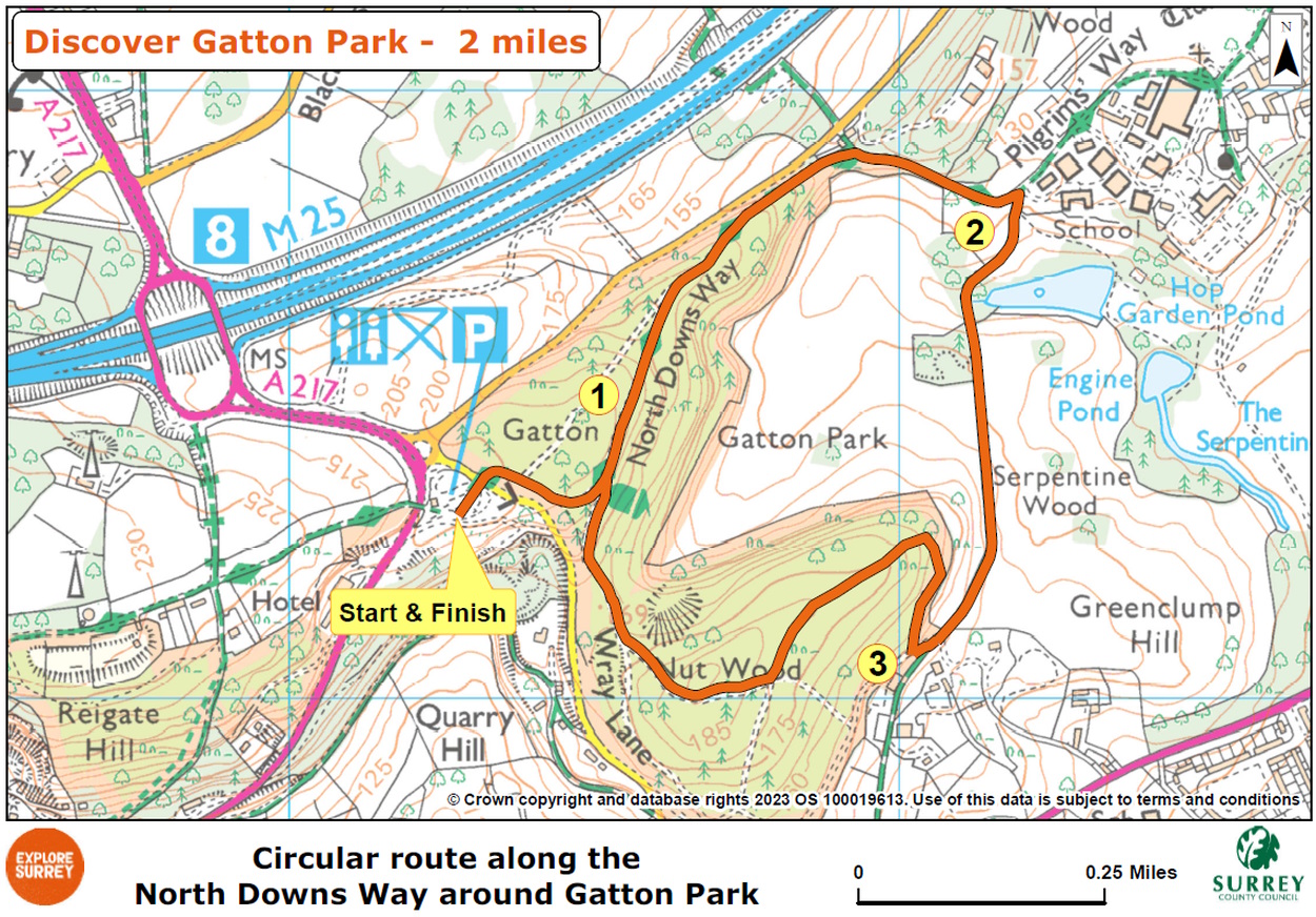
The numbers of each stage of the walk correspond with the points shown on the map.
Stages of the route
- Start at Wray Lane car park to the viewpoint
- Stage 1: Viewpoint to Stone Circle
- Stage 2: Stone Circle to Nut Wood
- Stage 3: Nut Wood to end of walk at Wray Lane
Start at Wray Lane car park to the viewpoint
From the car park, walk back towards vehicle entrance and join stone path just to the right which leads you to a crossing point on Wray Lane. Cross over and go ahead, passing the National Trust sign at entrance to Gatton Park. You are on the North Downs Way (NDW) national trail. Follow the path as it bends right and there will be a black metal post where the path splits into two. (This is the first of many posts along this circular trail that you will follow). Keep right, following the path downhill. The path divides again into two at Black Post 2, keep left here and follow the driveway as it bends steadily left to reach Black Post 3 at the edge of a fenced section of parkland. Keep straight ahead on the level path with fence running on your right. Soon you will come to a bench on the left at a viewpoint.
Stage 1: Viewpoint to Stone Circle
Continue along path with fence still on your right. Where the fence ends, keep ahead as path continues steadily downhill between trees. Further along, you will pass Black Post 4 on your left, standing beside a lone yew tree, continue on main carriage drive still descending steadily. Towards the bottom, the path runs close to a road on your left, so keep children and dogs close. At the bottom, the path leads you past white stone Tower Lodge on your left. Immediately after the lodge, you will see Black Post 5 marking a T-junction. Turn right to join tarmac vehicle access lane. Soon you will come to another bench on the right.
Follow vehicle track through gateway ahead and you will come to the Stone Circle within a pasture on your right. The first stone is inscribed with words from St John's Gospel and the subsequent nine stones are each inscribed with quotations, including Shakespeare and TS Eliot.
Stage 2: Stone Circle to Nut Wood
Continue along driveway as it goes to the left until you reach a signpost just before some houses. Turn sharp right here, leaving NDW to join signed bridleway and passing Black Post 6 on your left. Follow the bridleway leading you between fences with the Stone Circle to your right in the field. On the left you will pass one of the lakes within the parkland. From this lake, a series of linking ponds wind their way down the valley to the largest lake at the bottom. Beyond the lake the bridleway climbs steadily leading you through centre of the parkland, with views across the lakes and beyond to the North Downs ridge. At top of the slope you will come to some houses and farm buildings with a garden fence beginning on your left. A few metres along, keep right at the fork passing alongside the wide vehicle gate. Soon after you will see Black Post 7 on your left. Turn sharp right here to join the stone track leading steeply up into Nut Wood.
Stage 3: Nut Wood to end of walk at Wray Lane
Pass alongside the next wide gate and then stay ahead on the main track leading you steadily uphill. You will find another bench on your right with excellent views across the park and far beyond. Stay with the woodland path as it swings left and continues to climb. Eventually the path begins to level off, keep left to reach a wide wooden gate. Pass through gap to the left and you will come to T-junction with a bench on your right and Black Post 8 on your left. Turn right and follow track climbing steadily once again to reach the highest point in the park. Beyond brow of the hill, follow the main track which leads you down to a vehicle gate ahead. Pass through a gap to the right and stay with the path as it swings right with fence now running on your right. Keep ahead climbing steadily to reach Black Post 9 on your left. Keep right with the fence line on your right and continue until you reach next black post, this is Black Post 3 that you passed on your outward leg. From this point you will be retracing your steps back to the car park. To do this, turn left at Black Post 3 and stay with main path as it swings right, passing Black Post 2 and back to Wray Lane car park where the walk began. Refreshments, toilet facilities, benches and deck chairs available here for rest, with great views.
Go further
There is the option to extend this North Downs Way walk further to Colley Hill, you'll then be walking our Colley Hill and Reigate Hill walk (total 6 miles). Start at Reigate Hill Wray Lane and it becomes a figure of eight circular.
Map
Map shows the route from its start and finish points at National Trust's Reigate Hill Wray Lane car park. It joins the North Downs Way trail as it goes downhill towards Gatton Park and through the parkland, before climbing back up to the start point at Wray Lane. Select the map of the route below to open a larger version in a new window, that can be printed, if necessary, using your browser print tool with landscape selected. Alternatively, you can save the image to your mobile device, for reference on your walk.