About the walk
An easy-access 3 mile (4.5 kilometres) circular walk around a well-known beauty spot on the North Downs Way.

Route details
Please note: This walk follows public footpaths and bridleways which cross private and public land. Please respect people's privacy, keep dogs under control and remember the Countryside Code.
- Start and end address: Margery Wood National Trust (NT) car park, off A217 Sutton Road, KT20 7EJ (note charges apply for non NT members)
- Difficulty: easy
- Distance: 3 mile (4.5km)
- Type of walk: circular with spectacular views
- Approximate time: 1.5 hours
- Accessibility: Easy access. Some steep slopes that can be muddy and stony, but easy terrain, suitable for a robust buggy
- OS Map Explorer 146: Dorking, Box Hill and Reigate.
Description
Spectacular views, space to run around and picnic. Many places of interest including the Inglis Memorial and National Trust's Reigate Fort. You may also see Belted Galloway cattle grazing on the open land by the Inglis Memorial, they are used to people.
How to get there
Car: Margery Wood National Trust car park, minutes from J8 of M25, taking the A217 North towards Sutton, first left into Margery Lane. No pay machines, non NT members can pay using phone and debit cards.
Bus: No public transport to walk start point. However bus routes 420 and 460 stop at Reigate Hill/Wray Lane.
Facilities
- Toilets: Wray Lane car park (about halfway round)
- Refreshments: Wray Lane car park
Walk directions
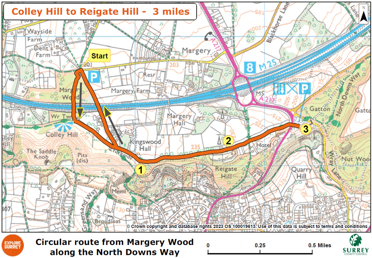
The numbers of each stage of the walk correspond with the points shown on the map.
Stages of the route
- Start to Inglis Memorial
- Stage 1: Inglis Memorial to Reigate Fort
- Stage 2: Reigate Fort to Wray Lane
- Stage 3: Wray Lane to end of walk
Start to Inglis Memorial
Leave Margery Wood car park to join woodland footpath, passing between low wooden bollards and then passing through a simple staggered fence to reach a fork. Take left-hand branch and follow this wide stone path steadily uphill through woodland until you come to footbridge over M25. Cross this and at far side, keep ahead along another short section of woodland footpath. Over to your left you will see a tall ornate brick water tower.
Please note: Beyond the next gate you may come across Belted Galloway cattle. Please keep dogs on leads and under control. They are used to people but we advise you to keep your distance and ignore them.
Go through the single gate ahead and you will meet a junction with North Downs Way (NDW) surfaced path. You are now on top of Colley Hill with magnificent views across the Weald to the South Downs. Turn left with views to your right and passing water tower on your left. Stay with this path and you will reach the Inglis Memorial on your right, a circular structure with columns. This unusual structure with its cobalt and gold ceiling showing an astronomer's view of the heavens, was originally built as a drinking fountain for horses.
Stage 1: Inglis Memorial to Reigate Fort
Go through the gate near memorial and continue on NDW, through a section of woodland. You will pass a World War Two pillbox on your right before coming to a clearing with a pair of aircraft wingtip sculptures and an information board. This memorial is the site of a World War II plane crash.
Further along, just after passing the tall masts of a transmission station on your left, you will come to the entrance for NT Reigate Fort on your right. Take time to explore the fort, but note that as sheep graze here, dogs are not permitted. Reigate Fort was built in 1898 as one of 13 mobilisation centres, established to protect London from invasion.
Stage 2: Reigate Fort to Wray Lane
Continue along NDW which now becomes a tarmac lane passing a few houses on your right. Just beyond these you will come to crossroads with a public bridleway. Go straight ahead, continuing on NDW which becomes a stone path once again.
Walk downhill (steepest gradient of this walk) to reach Reigate Hill footbridge. The single span footbridge, the earliest example of a reinforced concrete footbridge in the country, was built in 1910 by the firm Mouchel. Cross bridge and you will emerge into Wray Lane car park and picnic area which has a café kiosk and toilets. There are several picnic benches, deck chairs, a topography viewpoint and great views to enjoy.
Stage 3: Wray Lane to end
Retrace your steps back over Reigate Hill footbridge and follow NDW back past Reigate Fort, plane crash site and on to reach Inglis Memorial. Pass memorial (now on your left) and continue for about 170 metres to reach a single gate on your right. Turn right through this gate and join tarmac residential access lane directly ahead. Follow this quiet lane across M25 and then leading you gently downhill. At bottom of slope you will come to Margery Lane car park on your left where walk began.
Go further
There are options to extend this North Downs Way walk further to Gatton Park, you'll then be walking our Gatton Park circular walk (total 6 miles). Start at Reigate Hill Wray Lane and it becomes a circular figure of eight.
Map
Map shows the route from its start and finish points at National Trust Margery Lane carpark. It joins the North Downs Way trail at Colley HIll, goes to Reigate Hill Wray Lane car park and returns on a different M25 bridge. Select the map of the route below to open a larger version in a new window, that can be printed, if necessary, using your browser print tool with landscape selected. Alternatively, you can save the image to your mobile device, for reference on your walk.