Page Contents
About the walk
- Start address: Castle Hill, near Bletchingley village, approximate postcode RH1 4LA
- Distance: 5 miles
- Approximate time: 2 hours 30 minutes
- Grid reference: Castle Hill TQ320505, Oxted Place TQ382510
- OS Explorer map: 146
Walk directions
The following letters correspond to walk route points on the map.
A. Walk beneath a steep embankment and continue to the road. Cross the road and follow the footpath ahead between the houses to steps leading down to another road. Turn right. In 175 yards turn left at the entrance to a now-disused quarry.
B. In 22 yards turn left down a track beside a metal gate. Follow the gravel track leaving a pond to your right. In 275 yards turn right along a fenced path to go through old workings. Cross a concrete road and follow the track ahead ignoring side tracks. Keep left with the track and continue for 850 yards to the road.
C. Where the road bends left follow the track ahead. Walk past houses along a gravelled track, then continue along a field path right then left for 380 yards to a road.
D. Turn left. After 350 yards turn right along a bridleway and follow through woods to cross-tracks. Turn right and then left to follow the path below the hill, which is Tilburstow Hill, to reach the road after a thousand yards.
E. Turn right across the road and continue along a broad track below Brakey Hill for 820 yards, ignoring all turnings to the right until 10 yards before a gate across the track. Turn right just before the gate and walk ahead for 300 yards across the field, then keep left towards the top far left-hand corner. Cross a stile and follow the path ahead to the road (B2236).
F. Cross the road and turn left. Walk for 330 yards to a triangle where the main road bends left. Here turn right to pass Leigh Mill House on your left. Cross a footbridge beside a ford and after 330 yards continue ahead through a kissing gate to the Godstone by-pass (A22).
G. Cross the by-pass and go through a kissing gate ahead. Follow the path ahead for 950 yards to the road at Tandridge. Cross the road and turn right. Turn left after 80 yards and continue along a path to the right of the Barley Mow.
H. Follow the path round to the left, then keep right up a narrow path to the right of garages. Go through a kissing gate and walk along the top of a field to a kissing gate in the far left-hand corner. Keep right and follow the path ahead.
What to see
Bletchingley Castle: The de Clare family who were also Lords of Tonbridge built a solid castle here. It was demolished in 1264 during the war between Simon de Montfort and Henry III.
Tilburstow Hill: Once the place of Tilbeorht's Tree, the name of this hill has undergone almost as many changes as the valuable woodland which now covers it. Find out more about Tilburstow Hill, part of Surrey's Countryside Estate - note there are picnic benches here.
Leigh Mill, Godstone: Recorded as a corn mill in the Domesday Book, abandoned at the time of the Black Death, then used for gunpowder manufacture in the 17th century, the present brick and weather-boarded building dates from the 18th century.
Leigh Place Pond: Now a SSSI, this pond was first created when the Evelyn brothers dammed the Gibb Brook to maintain a steady water supply for the wheel at Leigh Mill gunpowder works.
St Peter's Church, Tandridge: A huge yew tree, said to be the oldest and largest in Britain, stands outside the church whose shingled bell tower has stood since around 1300 AD
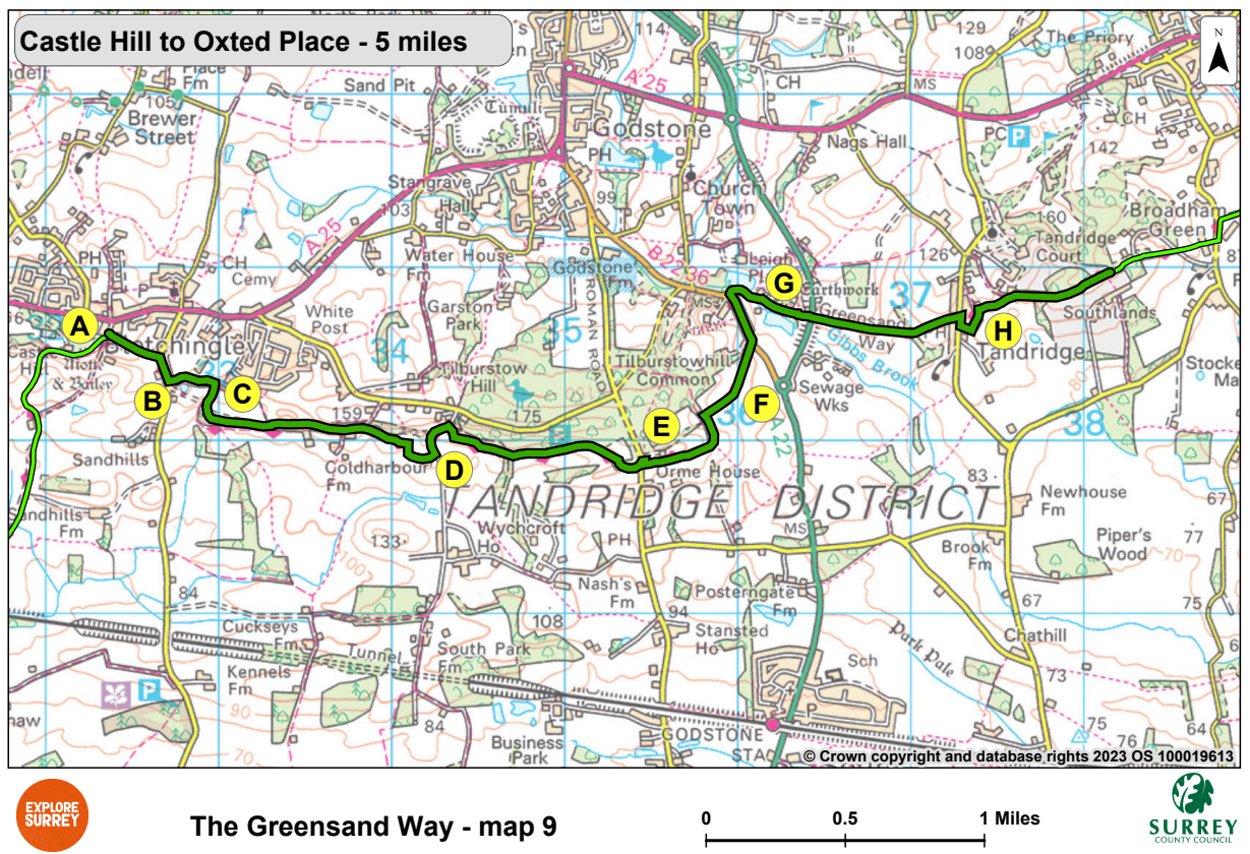
Map 9
Map nine goes from Bletchingley along the southern part of Tilburstow Hill below Godstone. It then goes on through Tandridge and Broadham Green towards Oxted Place where this section ends. Select the map of the route below to open a larger version in a new window, that can be printed, if necessary, using your browser print tool with landscape selected. Alternatively, you can save the image to your mobile device, for reference on your walk.