About the walk
A 7 mile (12.5 kilometre) linear 'rail to ramble' walk on chalk grassland from Dorking to Gomshall in the Surrey Hills, signposted with a distinctive 'Walk the Chalk' roundel. The scenery is spectacular and the area rich in wildlife.

Route details
Please note: This walk follows public footpaths and bridleways which cross private and public land. Please respect people's privacy, keep dogs under control and remember the Countryside Code.
- Start and end address: Dorking Station car park. Finish Gomshall Station (could be walked the other way round but signposting and directions are written as above)
- Difficulty: challenging terrain
- Distance: 7 mile (12.5 kilometre)
- Type of walk: linear 'rail to ramble' walk (start at one point and return by train)
- Approximate time: 3.5 hours plus travel time
- Accessibility: some kissing gates and steps, some steep slopes, can be slippery
- OS Map Explorer 146: Dorking, Box Hill and Reigate and 145: Guildford and Farnham
Description
In the first 3 miles you will walk on an old carriage road built in the 1800s by William Joseph Denison, one-time owner of Denbies House and Estate. Fossil sea urchins have been found here, a reminder that the North Downs was once covered by sea. Further along you will be walking on chalk grassland, which has developed as a special wildlife habitat due to grazing of animals. The chalk slopes are rich in orchids and chalk-loving butterflies such as Adonis and Chalkhill Blues.
How to get there
- Car: Dorking station has a large pay and display car park and Gomshall station has a smaller, free car park
- Train: Return journey between Gomshall and Dorking can be completed in one 7 minute journey, but check times before starting walk as service can be infrequent
- Bus: Compass route 32
Facilities
- Views: Many spectacular views
- Toilets: At Dorking station
- Refreshments: Dorking station and Lincoln Arms Inn at start, various pubs in Gomshall at the end of the walk.
Walk directions
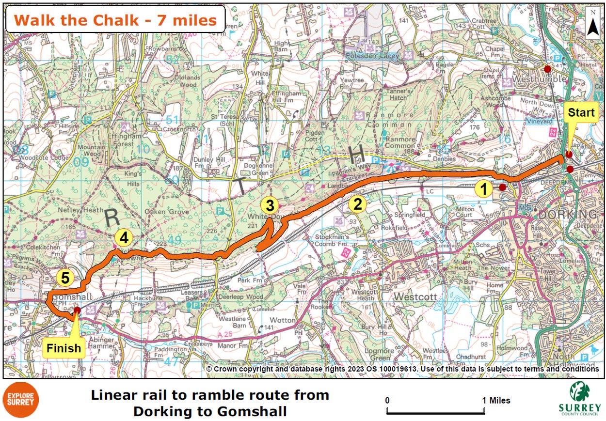
The numbers of each stage of the walk correspond with the points shown on the map.
Stages of the route
- Start to Denbies Hillside
- Stage 1: Denbies Hillside to Landbarn T junction
- Stage 2: Landbarn T junction to North Downs Way
- Stage 3:. North Downs Way to Beggars Lane
- Stage 4: Beggars Lane to Churchfield Track
- Stage 5: Churchfield Track to Gomshall Station
Start to Denbies Hillside
Leave Dorking station with the Lincoln Arms opposite, walk down subway and follow to far end, then take steps swinging right back to pavement alongside dual carriageway. Turn left along pavement, heading towards traffic lights. At traffic lights, turn left along Ashcombe Road (A2003) passing Ashcombe School on left. At top of road you will come to mini roundabout. Go straight ahead, signed to Ranmore. Soon afterwards you will come to T-junction. Cross over, turn right along pavement (still signed to Ranmore). Shortly, where pavement ends, fork left onto public footpath which skirts grounds of St Martin's School on left. At end of school playing fields, you will see a footpath on left and a National Trust (NT) sign for Denbies Hillside.
Stage 1: Denbies Hillside to Landbarn T junction
Turn left here, following path past NT sign. Follow main path (ignoring any forks) and you will emerge to T-junction with larger track, turn left. Ignore any paths off to left and right and carry on along track for next two miles, climbing steadily for first half and then descending steadily for second half. Path swings hard left to reach T-junction with another track (with fence line and open field ahead). This is the access track to Landbarn Farm, where NT Surrey Hills West Team is based.
Stage 2: Landbarn T junction to North Downs Way
Turn right along track and pass through gate. Note: this area – and several others from this point on – may be used for conservation grazing so take care with dogs. Follow track ahead, following fence line on left. Continue on this track for a mile, ignoring any paths signed off left and right. After a mile, track swings hard right to reach T-junction with a signpost (signed with white and green 'Walk the Chalk' signpost). Turn right here to join a chalk track which leads uphill (heading back on yourself ) with bank of yew trees on left. Towards top of hill is a handy bench, known as God's Seat, catch your breath here and admire the views. Continue to top of slope to junction with gate ahead and pillbox on right. You are now joining the North Downs Way (NDW).
Stage 3: North Downs Way to Beggars Lane
Turn left along NDW. Follow this path passing several more pillboxes. Viewpoints along the North Downs were strategically important during World War11, which is why so many pillboxes were built here. Eventually path swings right to reach T-junction with a road, White Down Lane. Turn right for a few paces and then left off road to re-join NDW. Follow path winding ahead and go straight on at crossroads, passing through kissing gate to enter NT area of White Down Lease. Keep ahead past several more pillboxes. At end of this section, pass information board on left then go through 2 kissing gates in quick succession to continue on NDW through Blatchford Down.
At end of this section of downs, go through kissing gate and ignore bridleway on left; simply keep ahead on NDW. Keep ahead along next stretch of path with fence on left. When fence ends, you will come to crossroads with an ancient public byway known as Beggars Lane.
Stage 4: Beggars Lane to Churchfield Track
Go straight ahead, continuing on NDW. Take first kissing gate on left, signed as public footpath. You are now leaving NDW and entering Hackhurst Downs. The path soon swings left, becoming grass path running steeply downhill across hillside. You will pass a well-placed bench, continue steeply downhill (NB chalk can be very slippery). At bottom of slope, pass through two gates in quick succession, pass NT sign for Hackhurst Downs and follow path diagonally downhill. At the bottom corner, walk through a weighted gate and continue steeply downhill through a small belt of trees. Continue through dip and then follow signposted footpath past fenced pastures and to a crossroads with access track for Churchfield Farm, part of the Wotton Estate.
Stage 5: Churchfield Track to Gomshall Station
Go straight ahead at this crossroads, through two kissing gates. Further along, the path goes between steep banks down to T-junction with a road, Colekitchen Lane. Turn left along lane taking care of any traffic. You will come to T-junction with main A25 road. Turn left and follow this road through Gomshall, where you will find a choice of pubs, coffee shops and restaurants. Carry on until you reach Station Approach on left, just before railway bridge (bus stop here where you can catch a bus back to Dorking, check times beforehand). Walk up Station Approach and you will be at Gomshall Station.
Map
The map shows the route of the 7 mile walk, that starts from Dorking Station onto Denbies Hillside, carries on to the Landbarn T junction, then onto the North Downs Way to Beggars Lane to Churchfield Track and finishes at Gomshall Station. Select the map of the route below to open a larger version in a new window, that can be printed, if necessary, using your browser print tool with landscape selected. Alternatively, you can save the image to your mobile device, for reference on your walk.