About the walk
The Deer Trail is a 5.5 mile scenic and hilly walk around several well-known beauty spots in the Surrey Hills National Landscape and on parts of the North Downs Way near Guildford.

Route details
Please note: This walk follows public footpaths and bridleways which cross private and public land. Please respect people's privacy, keep dogs under control and remember the Countryside Code.
- Start and end address: Newlands Corner, Albury Downs, GU4 8SE
What3Words: just.renew.assure
Location grid reference: TQ044493 - Difficulty: challenging
- Distance: 9 kilometres, 5.5 miles
- Type of walk: circular, spectacular views
- Approximate time: 3 hours
- Accessibility: not accessible, steep slopes, steps, two stiles, gate and can be muddy
- OS Map Explorer: 145 Guildford and Farnham covers this walk
Description
This route takes the walker round or near many historic landmarks such as the Norman church of St Martha's, the only church in Surrey on the historic Pilgrim's Way. Chilworth village lies below the church and the Tillingbourne River, with its famous gunpowder mills dating from the 17th century. The route back to Newlands Corner takes the walker past the famous Silent Pool, place of myth and legend and up onto the North Downs Way, on your left you will find the Optohedron 'Inspiring Views' sculptural seat.
How to get there
Bus
Route 25 serves Guildford to Newland Corner, at point 2 of this walk.
Train
Chilworth Station about a mile from point 4 St Martha's Church.
Car
Free parking is available at both :
- Albury Downs main car park, GU4 8SE
- White Lane car park, GU5 9BQ
If you wish to start the walk at point 2 on the map for St Martha's Hill, use the Halfpenny Lane car park and join the route by following the North Downs Way trail sign up the steep bridleway to the church:
- Halfpenny Lane, Guildford GU4 8PZ
OS grid reference: TQ028483
What3Words: mash.puts.plots
Facilities
- Toilets: Newlands Corner (open 9am to 4pm); Silent Pool distillery
- Refreshments: free water fountain Newlands Corner, refreshment window open 9am to 4pm. Albury Vineyard, Silent Pool distillery and other small businesses at Silent Pool (check opening times)
Walk directions
The numbers of each stage of the walk correspond with the points shown on the map.
Stages of the route
- Stage 1: Start at Newlands Corner main car park to Keepers Cottage
- Stage 2: Keepers Cottage to St Martha's Church
- Stage 3: St Martha's Church to Water Lane
- Stage 4: Water Lane to Silent Pool
- Stage 5: Silent Pool car park to North Downs Way
- Stage 6: North Downs Way trail to Newlands Corner
Stage 1: Start at Newlands Corner main car park to Keepers Cottage
Walk the length of the entire car park to pass alongside the vehicle barrier and take the bridleway path in the open grassy area. At the far end of the bridleway continue directly ahead on the obvious path running along an avenue within woodland. Continue on this woodland track.
Further along track look out for a signpost on right marking a permissive horse ride. Do not take this, instead keep ahead for 10 metres to reach small signpost on your left. Turn left and follow path into trees. Path swings right leading you under several large yew trees. Look for next signpost and follow arrow onto path swinging steadily left downhill and you will emerge into White Lane car park.
Cross over and take the path directly ahead. The stone path swings left. At next signpost turn sharp right onto a stone path heading downhill through trees. Keep left at fork and be aware you are approaching a road, after a staggered barrier. Cross over with care and take steps directly ahead. At top, path swings left to run parallel with road on your left. Stay with this roadside path as it leads you steadily downhill on an uneven path until you reach the T-junction with Keepers Cottage ahead - a half-timbered black and white cottage.
Stage 2: Keepers Cottage to St Martha's Church
Turn left alongside gate and then immediately right onto a stone track signed NDW, keeping the cottage on your right. Soon after fence ends on your right, you will pick up the next Deer Trail signpost. Stay with this path leading to a major junction, marked with a multi-way North Downs Way signpost. (At this point you are doing a loop up to the church, round the church perimeter and returning down this same track right to the bottom and Guildford Lane car park). Turn right here to join permissive horse ride, marked as the Deer Trail. Follow main obvious path and as you pick up next signpost, stay with the trail bearing left heading uphill to reach a T-junction. Turn right and you will pass a stone boundary marker dated 1933. 20 metres later, turn left onto a steep sandy uneven path leading you uphill once again. At the top of the hill you will come to St Martha's Church ahead.
Stage 3: St Martha's Church to Water Lane
Turn left immediately before church, joining NDW once again and passing church on your right leading you to southern edge of the hilltop. Superb views and benches to rest on here, with the church and its walls behind you, where there are more benches. The two villages in the valley below are Chilworth (ahead) and Albury (left). Follow the church wall around to keep the church on your right and turn left at the gate to the church to return down the same wide sandy path leading you fairly steeply downhill, taking you back down the same track you followed to reach the church. Stay with the main path heading downhill, ignoring all side paths. Towards the bottom you will pass a brick pillbox on your left and, soon afterwards, the path leads you into an open grassy area and then directly into St Martha's Hill car park on Guildford Lane.
Cross car park and turn right along Guildford Lane for 50 metres and then turn left to join a public bridleway signed Deer Trail. Stay with left-hand fence line, further along the path leads you past woodland on your right. Beyond woodland you will come to a crossroads with grass track. Go straight ahead through gap in hedge and walk diagonally right across field. As your path reaches right-hand fence line, fork right between old gate posts to join a narrower path into trees and scrub. Stay with path as it leads steadily downhill and then steeper to reach junction with sunken lane, Water Lane.
Stage 4: Water Lane to Silent Pool car park
Turn left and then immediately right to join stone access public bridleway. After passing the house on right, keep directly ahead alongside gate and follow path between fields. Simply follow this path climbing steadily and you will reach a house on your right, 'Timbercroft'. Continue ahead, passing house and smallholding paddock on left. Beyond this paddock, follow vehicle track ahead and at fork, bear right to join smaller path leading you through trees. You will come to a junction with concrete access track for waste facility site, so take care of any lorries. Cross over and continue ahead on the woodland path.
When you reach a stile, cross it into field (please note: if holding livestock, keep dogs on leads) and walk straight ahead following left-hand fence line. Another of Albury's churches (the gothic Apostolic church) is ahead and to your right. At the far side cross the stile and go through a kissing gate to reach A248. Cross over with care and turn left along the pavement, which is separated from road with hedge. You will come to a junction with the A25 dual carriageway. Use designated crossing point to cross dual carriageway and you will come to the Silent Pool car park.
Stage 5: Silent Pool car park to North Downs Way
From Silent Pool car park, take the path which starts between two noticeboards. Follow this path to reach junction with vehicle track (Albury Vineyard entrance to your left). Stay with fence on your right as path leads past Sherbourne Pond. At junction in path you will come to Silent Pool ahead, with a handy bench to sit and enjoy the atmosphere. Turn left up a flight of wooden steps to reach T-junction with higher parallel footpath. Turn right along this, with vineyard running on your left. Stay with mainly chalk path as it climbs steeply up to join North Downs Way. Safety note: path can be very slippery, a walking pole may be helpful.
Stage 6: North Downs Way trail to Newlands Corner
At top of the steep trail, turn left to join North Downs Way (NDW) heading west. You will pass a signpost for the Deer Trail. For this stretch, NDW follows a fairly level wide track, which can be muddy in wet weather. Further along on your right, you may want to rest on the 'Optohedron Inspiring Views' sculptured bench. Stay on the track until you emerge alongside a vehicle barrier and junction with the A25. Cross over this very busy road with care and enjoy the spectacular views for which Newlands Corner is well-known. Follow the stone path to the main Newlands Corner car park where this walk ends.
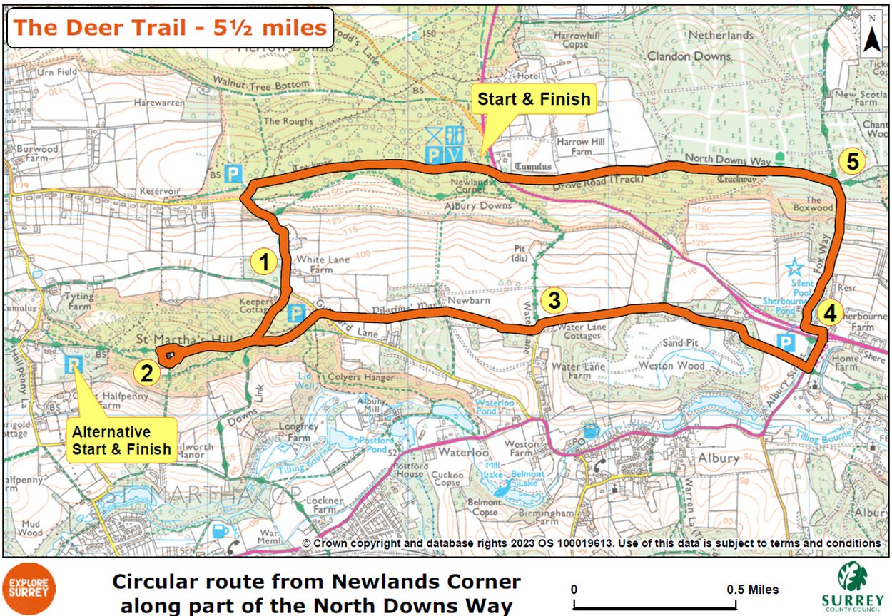
Map
The map shows the route for the 5.5 mile walk that starts at Newlands Corner car park and progresses in an anti-clockwise direction to St Martha's Hill and church to the west (with alternative start point). It continues along the bottom of the hill towards Albury village where the route crosses the A248 to the famous Silent Pool, then climbing steeply to the North Downs Way (a walking pole may be useful) before returning to Newlands Corner. Select the map of the route below to open a larger version in a new window, that can be printed, if necessary, using your browser print tool with landscape selected. Alternatively, you can save the image to your mobile device, for reference on your walk.