Page Contents
About the walk
- Start address: Witley railway station, Station Approach, Wormley, GU8 5TB
- Distance: 6 miles
- Approximate time: 3 hours plus
- Grid reference at end section Gatestreet Farm: Grafham TQ011419
- OS Explorer maps: 133 and 145
Walk directions
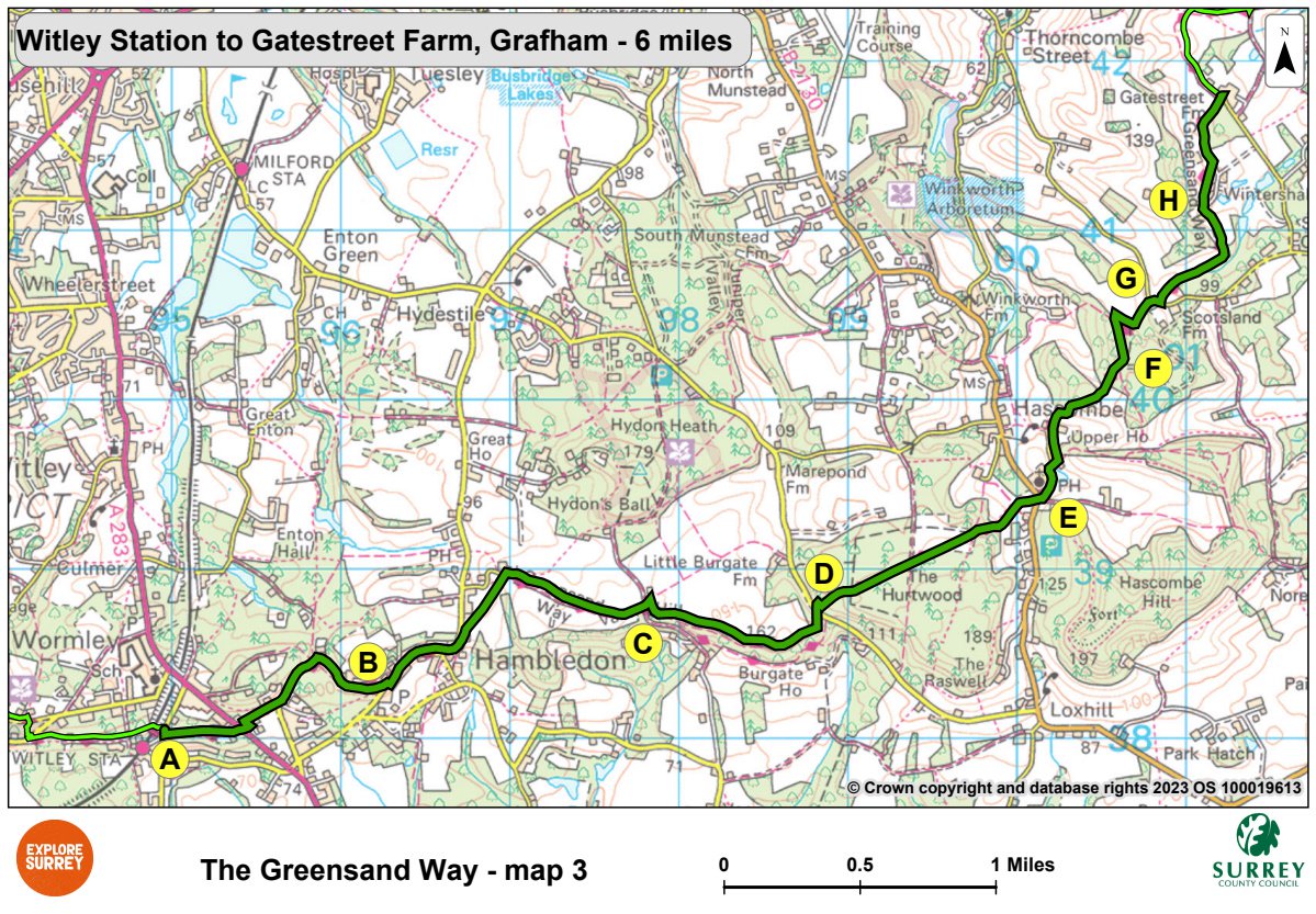
The following letters correspond with the route directions on the map.
A. Cross the road and turn right (or left if coming from Witley station). Turn left (or right if coming from station) along a footpath opposite Robin Way. Turn left along the road (A283) for 30 yards, then turn right up a side road for 300 yards. Turn left up a sandy track. After 380 yards turn right at Moor Cottage and continue uphill. Follow the footpath around the hilltop above Hambledon Common. Pass an old seat, then turn left down to the road at Hambledon.
B. Turn left along Malthouse Lane. Go past Woodlands Road on the right and after 100 yards turn right up some steps behind cottages. Turn right through kissing gates over fields to turn right past Hambledon Church. Keep right through the car park along a broad track. After 930 yards turn right at a T junction. In 30 yards turn left up a narrow path.
C. Walk beside the wood edge, then turn right down hill through woods along a broad path for 220 yards. Take the left fork and continue below the woods of Burgate Hangar for almost half a mile to Markwick Lane.
D. Turn left along road for 80 yards, then turn right up a steeply banked track. When you reach level ground, continue along broad track for just over half a mile, ignoring all side tracks. Just after the path starts to descend turn right at path junction, then in 20 yards turn sharp left onto descending path that gradually broadens right through beech hanger. In 190 yards, as the track starts to turn right, keep left onto steeply descending footpath to go through gate at bottom. Walk along edge of field, go through gate to reach bridleway. Walk straight ahead to main road opposite the White Horse Inn in Hascombe village. Cross road and take side road to the left of the Inn.
E. Follow the road past St Peter's Church and the pond. Turn left and continue to the road end. Go ahead through the gateway and walk up a drive. Go through a smaller gate onto a sandy track uphill. Keep ahead to go past a barn into woodland. Ignore a left fork and continue to cross tracks.
F. Turn left along a broad path, then turn right after 300 yards down a deeply sunken path. Turn left at a T-junction to follow the track to the road. Turn right and walk along the road for 45 yards. Turn left, 110 yards before the barn of Scotsland Farm along a footpath between hedges. Continue through coppiced woodland and follow the path left into a field. Go ahead onto a farm track out of the field in the far left-hand corner.
G. Follow the track downhill through the Wintershall Estate, then veer left up a grassy track between firs. Cross a gravel track, go through gate and then head downhill across the field, leaving tennis courts to your right towards a concrete farm track by a right-hand fence. Turn left along the farm track, past farm buildings and continue along a broad track with woods on your right, to Gatestreet Barn. Turn left at the road.
What to see
Hambledon Village Shop was purchased by the Hambledon Village Trust in 2003, this shop is now run by the people of the village as a Post Office, grocers and small tea-shop.
Burgate Hangar. The slopes of Burgate Hangar have been made steeper by landslips. They now provide a spectacular setting for hanging beeches with far reaching views.
St Peter's Church, Hascombe was rebuilt by Henry Woodyer in 1864 and the chancel roof is designed as an upturned fishing boat. A stained glass window depicting the patron saint continues the fishing theme.
Hascombe Village: The village pond has served as both fish-pond and millpond in its time.
Map 3
Third section of the Greensand Way route starting at Witley station, on to Hambledon and its church, into Burgate Hangar and Hascombe Village. Go on past Scotsland Farm and into the Wintershall Estate and Gatestreet Farm. Select the map of the route below to open a larger version in a new window, that can be printed, if necessary, using your browser print tool with landscape selected. Alternatively, you can save the image to your mobile device, for reference on your walk.