Contents
About the walk
- Start address: Reigate Priory Park, Bell Street, RH2 7RL
- Distance: 7 miles
- Approximate time: 3 hours 30 minutes
- Grid reference: Reigate Park TQ247494, end of section at Castle Hill TQ320505
- OS Explorer map: 146
Walk directions
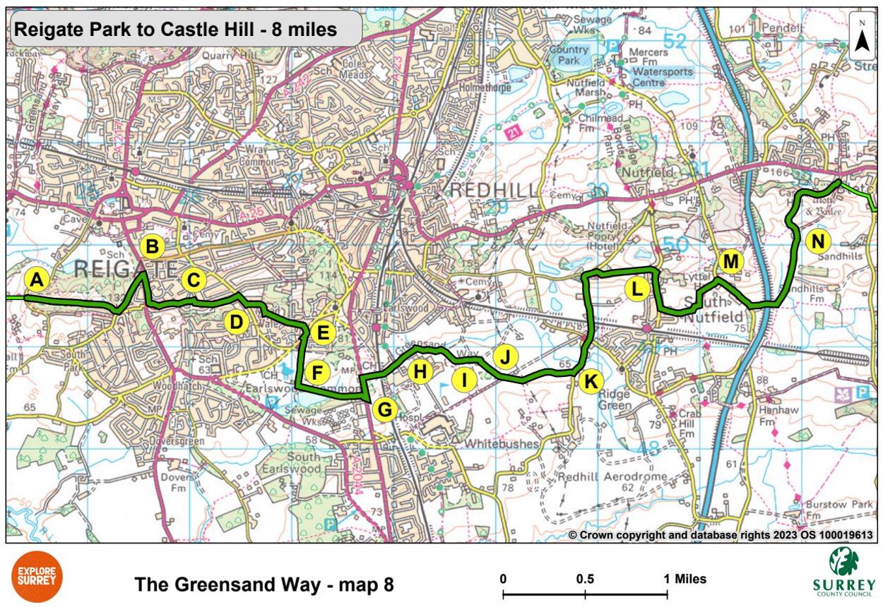
The following letters correspond with the route directions on the map.
A. Go ahead along a broad sandy track across Reigate Park, passing seats on your right. Walk past a monument, ignoring a right-hand path just before it. Walk downhill through trees. Just before reaching a minor road on your right, turn left along a metalled path to reach the main road (A217).
B. Cross the road at the traffic island. Turn right, crossing St. Mary's Road and Lymden Gardens. Walk left up Isbells Drive, terraced above the main road, continuing on a narrow metalled path to reach the end of a cul-de-sac.
C. Continue along the cul-de-sac, passing Orewell Gardens on your left. At the start of Hilltop Road on your right go ahead on the path between fences. Turn right at a junction in front of a garage then left at metal barriers. Cross Furzefield Crescent keeping to the left of a green. Cross Cornfield Road and continue ahead along a gravel path between garden fences. Take the left fork and walk along a sandy track to the left of woodland.
D. Turn right at a road (Cronks Hill), crossing it to turn left into Cronks Hill Road. Take the second path on the left through metal barriers (opposite Hollowdene). Continue until you reach the edge of Redhill Common. Turn right just past The Lodge then left onto a drive to reach a road.
E. Cross the road at the bus stops then just to the right of Abinger Drive turn left onto a path between trees. At a cross track keep ahead to a golf course. Keeping to the left of a small clump of trees by the 18th tee and to the right of a green, head a short distance down the left-hand side of a fairway to reach a gravel path at a gap in the trees. Continue along this path until you reach a raised tee with steps. Pass to the left of this, continuing along a sandy track.
F. Turn left at cross tracks and walk along a raised bank with Earlswood Lake on your right. At the end of the lake cross concrete steps and continue through trees towards woodland and another part of the golf course. Keep left between fairways along a gravel path, passing to the right of two stepped tees. Turn right at a green to reach a road (A23).
G. Turn left along the pavement. After 300 yards cross the road and follow the road opposite through metal bollards. Go under the railway bridge then keep left along a road passing the Royal Earlswood Day Nursery on the left.
H. Passing two lodges to your right go straight ahead along a path at the point where the road continues to the right.
I. Turn right at a junction of tracks. Walk along the footpath with Redhill Brook on your left, ignoring a stile on your right by a pond. Cross the next stile then go ahead across a field to a gap in a fence. Keep left across a field then fork left to reach a stile. Cross this then keep left on a path between wire fences. Go over a stile, cross a concrete road and go straight ahead on a concrete path past the site of Old Garstons House.
J. Go through a kissing gate then continue to your right across a field towards electricity poles. Cross a stile and follow the path through a coppice. Turn left along a metalled track. After 20 yards continue to the right across a field, passing a solitary tree to your left. Go through a gap in the hedge and follow the footpath for 600 yards to a stile.
K. Cross the road and turn left. Just after Mill Cottage keep right along the old road. Cross Kings Mill Lane and go ahead up Bowerhill Lane. At the top turn right as a small road enters from your left. Just before the road descends turn right between wooden posts. Go through gate and up to a stile. Cross the stile then follow the path along the hillside. Cross the next stile and continue to the road.
L. Turn right down the road. After 405 yards, beside house no. 124, turn left across the road and walk ahead along a gravel track. Cross the stile and follow the path up the left side of the field. At the field corner, cross stile and walk with the hedge on your right. Cross two stiles and turn left along the hedgeline. Cross the stile, then keep to your right diagonally to a stile in the right-hand corner of the field.
M. Turn right at the road. In 480 yards turn left along a drive and walk past Colgates Barn Cottages. Walk under the motorway (M23). Cross the stile and follow the farm track round and uphill for 830 yards.
N. Walk past some barns then, after 27 yards, walk to the left. Cross the right-hand stile and follow the path between fences uphill keeping right below Castle Hill.
What to see
Reigate Park: A memorial commemorates Mr and Mrs Randall Vogen's gift of the park to the corporation in 1920.
Reigate Priory: A priory was founded here in the 13th century for Augustinian canons. After the Dissolution of the Monasteries, Lord William Howard converted the buildings into a Tudor mansion.
Reigate: After the castle was built in 1088, a town grew up known as Reigate, 'the gap through which Roe Deer were hunted'. The town replaced the earlier village of Cherchefelle for which St Mary's Church was first built.
Redhill: The low-lying land, once the preserve of farms and tiny hamlets, was transformed into a residential area by the arrival of the railway - the London, Brighton and South Coast Railway in 1841 and the South-Eastern Railway between 1842 and 1849.
Earlswood Common: Held by the first Earls of Surrey, this was part of the wastes of the manor of Reigate and remained common land until the 19th century.
Nutfield Priory: Prominent on the hillside, Nutfield Priory looks like a Tudor building. It was built in 1872 by the architect John Gibson, as a private house in a style favoured at the time.
Nutfield: The area has long been known for its resources of fuller's earth, much of which is now exhausted. A nature reserve has been created on the site of old processing plants.
Map 8
Map Eight is one of the longest sections. It starts in Reigate Priory Park and continues on residential streets until you reach Redhill Common, followed by Earlswood Common and lakes. The route then continues on towards South Nutfield, under the M23 and up Castle Hill, just outside Bletchingley village. Select the map of the route below to open a larger version in a new window, that can be printed, if necessary, using your browser print tool with landscape selected. Alternatively, you can save the image to your mobile device, for reference on your walk.