Page Contents
About the walk
- Start address: Viewing platform with landmarks at the top of Pitch Hill
- Distance: 7 miles
- Approximate time: 3.5 hours approximately
- Grid reference: Pitch Hill TQ083423, end of section at Broadmoor TQ136457
- OS Explorer map: 145 and 146
Walk directions
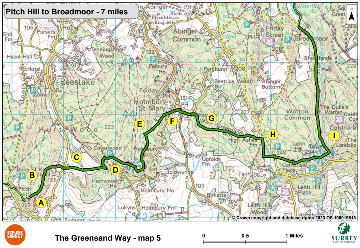
A. Pass the viewing platform showing landmarks and cross the open area to take the narrow path ahead and follow it until a path joins at an acute angle from the left. Turn back left along this path and follow it downhill along the hill edge. At a joining path, keep right and follow this path past a seat. Just past the seat where the path goes uphill, keep right down a narrow path to meet a metalled track.
B. Turn left onto the metalled track. Go through a metal barrier and continue along a broad track. Pass a footpath entering from the right and then turn right at the next footpath. Follow the footpath downhill, then go down steps to the Duke of Kent School. Turn left along the drive.
C. Cross the road and take the footpath ahead into woodland. Follow the fenced path up a slope to a stile. Continue on a fenced path across fields and at the top of a slope keep right along a drive and go through a wooden barrier. Turn sharp left along a track going uphill and turn right at the first turning. Follow this path for a short way to a road, cross it and go into Hurtwood Control car park (number 1).
D. Turn right to leave the car park and cross a gully. Go up steps and follow the footpath ahead uphill. After 540 yards cross the rampart of Holmbury Hill Fort. Make for the memorial seat on the summit and enjoy the view. Follow the path skirting the hillside down to wooden barriers, then turn left. Continue along the hillside and then downhill. Swing left to merge with a broad track after 560 yards. Turn right at a junction of five tracks.
E. Follow a broad path past a cricket pitch on your left. At next junction, fork right and follow track down to Holmbury Hill Road. Turn left and then turn right after 80 yards where the road forks and continue to the main road (B2126 Abinger Hammer to Horsham).
F. Turn right, then first left. After 260 yards turn right up a rough sandy track and follow the undulating path for one mile.
G. Walk uphill to pass High Ashes Farm on your left. Ignoring a downhill right-hand turn, continue to the T-junction.
H. Turn right along a gravel track. Ignoring paths to left and right, continue to a T-junction. Turn left. Keep right across the road. Go ahead up a broad track to reach Leith Hill Tower after 980 yards. There is a refreshment kiosk in the base of the tower, check NT website for opening times. Walk ahead past the tower, going downhill, for 220 yards.
I. Turn left at a junction of five tracks. Walk downhill for 1.5 miles, continuing ahead where the track goes back to Warren Farm. Turn right and walk along a lane for 15 yards.
Broadmoor car park is located near here, approximate postcode RH5 6JY.
What to see
Duke of Kent School: Built in 1885, by Ernest George and Peto, the school still has tiles made by Dalton's Tile Works.
Holmbury Hill: Not long before the Roman Conquest, Iron Age Celts settled on Holmbury Hill, building a fort that covered eight acres. Roughly cleared hearths suggest they had to abandon the fort in haste.
Leith Hill Place Wood: Leith Hill Place Wood is one of the few areas where ancient semi-natural woodland has survived. Like other woods along the scarp face it provides a habitat for rare birds.
Leith Hill Tower: Mr Richard Hull, who lived at Leith Hill Place, gained permission from Mr Evelyn of Wotton to build a tower as a Prospect House in 1765. It was later raised to 1,029 feet. Thirteen counties may be seen from the top on a clear day and it's the highest point in southeast England.
Tilling Springs: The well-known River Tillingbourne rises on the dip slope as springs emerge from the junction of the Hythe Beds and the Atherfield Clay.
Map 5
Map five covers the area from the top of Pitch Hill, through the grounds of Duke of Kent school and on to the Hurtwood Control. Passing remains of Holmbury Hill fort and the viewpoint, the route descends towards Holmbury St Mary (but not to the village itself). Pass High Ashes Farm to the path leading to Leith Hill Tower, going past the tower and then downwards towards Broadmoor (and the car park) where this section ends. Select the map of the route below to open a larger version in a new window, that can be printed, if necessary, using your browser print tool with landscape selected. Alternatively, you can save the image to your mobile device, for reference on your walk.