Page Contents
About the walk
- Start address: Oxted Place, approximate postcode RH8 9PF
- Distance: 4.5 miles
- Approximate time: 2.5 hours
- Grid reference: Oxted Place TQ382510, county boundary at Goodley Stock, Limpsfield
- OS Explorer maps: 146 and 147
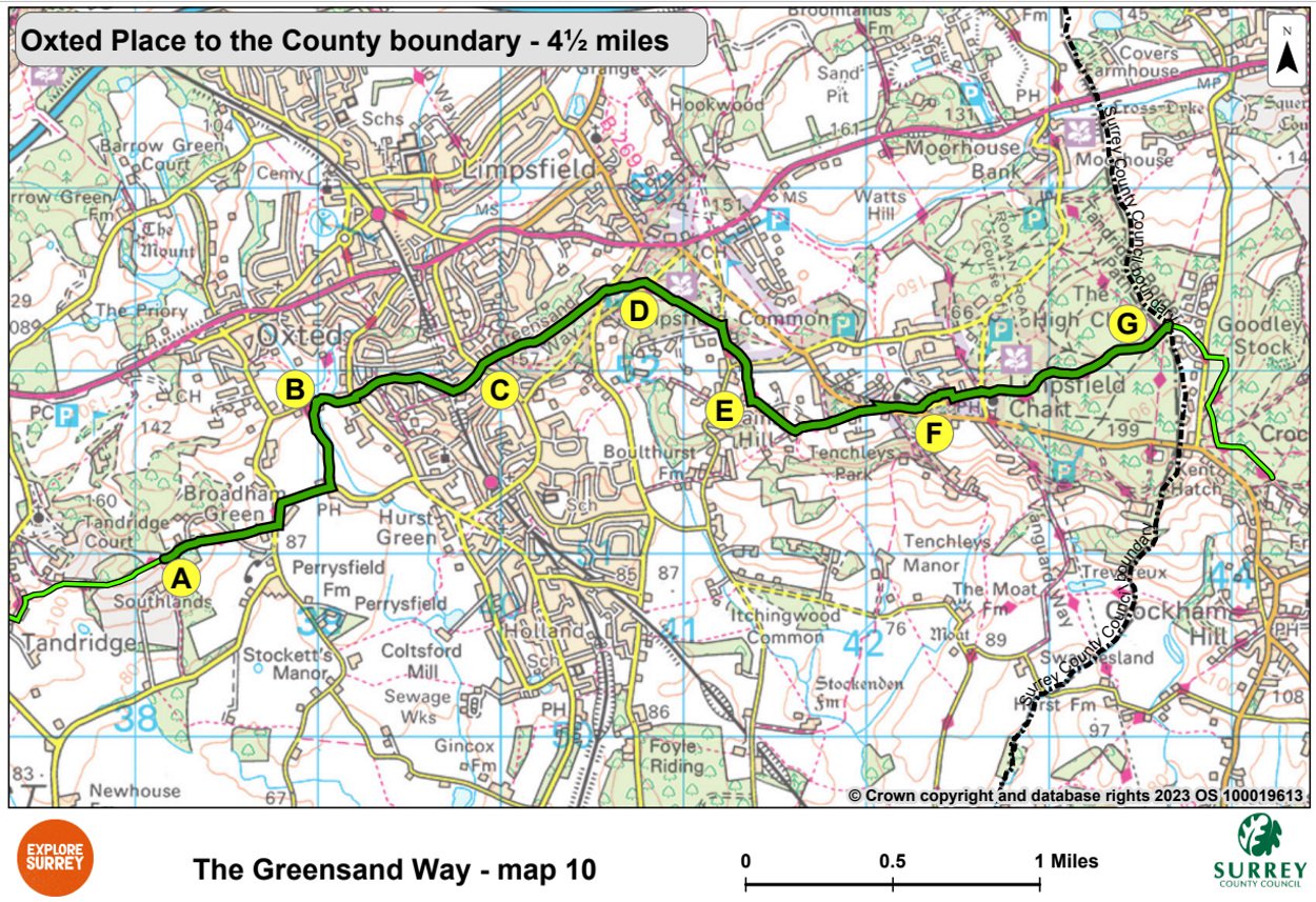
Walk directions
The following letters correspond to walk route points on the map.
A. Continue along a metalled track at the entrance to The Mount. Cross the drive and continue to the road at Broadham Green. Turn left along the road then right along Tanhouse Road. Turn left and cross a stile opposite The Hay Cutter pub. Walk along the right-hand side of the field to a stile. Cross this then keep left and follow the path through a kissing gate to a complex of buildings at Oxted Mill.
B. Continue to Spring Lane. Turn right along the road and walk uphill to Woodhurst Lane. Cross and go up the narrow path on left. Walk for 400 yards between gardens then along a metalled drive to a T-junction.
C. Turn left along the road. After 220 yards cross Rockfield Road and follow the bridleway ahead. At the entrance to Limpsfield Common take the left fork up to a metalled lane with Limpsfield Common on your right. At St Michaels, cross Wolf's Row and walk over the common to New Road.
D. Cross the road and follow the main track over the common to Brick Kiln Lane. Keep right along the road, then after 120 yards take the footpath on your left and cross the golf course diagonally for 50 yards.
E. Cross the road taking the footpath to the left of Pains Hill Chapel and follow it to Pastens Road. Turn left and walk to the end of the road. Turn left along a gravel lane at Pastens Cottage and continue along the footpath ahead to the road at Limpsfield Chart.
F. Cross Kent Hatch Road, turn right and walk along the tarmac path for 270 yards. Cross Ridlands Rise and go ahead along an unmade road to another road. Keep left, pass The Carpenter's Arms pub and follow footway to a T-junction.
G. Cross and follow the footpath ahead, then after 250 yards keep left. Follow the path for about two thirds of a mile, going over three broad cross-tracks. Keep left at the next junction and continue to a meeting of six tracks at the county boundary. Take the track ahead between houses to the road at Goodley Stock. Cross the road to a stile and walk across a clearing to a track.
You are now in Kent's section of the Greensand Way and can find directions and maps for this at: Explore Kent.
There are various car parks close to either side of the county boundary.
What to see
Oxted Mill: A water mill has stood here since the mid-19th century, with an extension built in 1893. This was powered by a turbine and produced much finer flour than before.
Former St Michael's School for Girls: At point C of the walk you will see the Gothic tower of this red-brick building, built in 1886.
Limpsfield Common: When the Lord of the Manor first tried to establish brickworks here in 1830 he caused uproar among the Commoners who had held rights since the 14th century.
Map 10
Map ten is the final section of the Greensand Way in Surrey. Starting at Oxted Place near Broadham Green and south of Oxted, it continues on past Limpsfield Common towards Limpsfield Chart. It continues across the Chart to Goodley Stock and the county boundary, where this section ends. Select the map of the route below to open a larger version in a new window, that can be printed, if necessary, using your browser print tool with landscape selected. Alternatively, you can save the image to your mobile device, for reference on your walk.