Page Contents
About the walk
- Start address: Gibbet Hill at the Celtic Cross, Hindhead Common
- Distance: 6.5 miles
- Approximate time: 4 hours plus
- Grid reference: Gibbet Hill SU899360
- Use OS Explorer map: 133
Walk directions
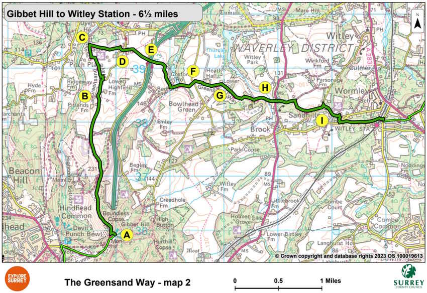
The following letters correspond with the route directions on the map.
A. Walk ahead past the Celtic Cross. Start downhill then turn left into a beech wood along a broad surfaced track. Continue downhill on an unsurfaced track for 875 yards to where the old A3 road used to run (now a surfaced path). Cross over and turn right up a broad track then follow the main track along the side of the Devil's Punch Bowl. Continue over the heath, gradually descending for 950 yards down an unsurfaced track. Where the tracks cross just before trees, walk ahead along a sunken path beside woodland, to the road.
B. Turn right along the road. After 400 yards, turn left through the gate to the right of Hedge Farm. Where the main driveway turns left, go ahead along a narrow path. Continue round the garden hedge and turn right, going over stiles. Follow the field edge for 450 yards, crossing a stile half-way down. Cross a stile at the bottom of the field, turn left, then right and go down a narrow lane to Smallbrook Farm.
C. Turn right into the field opposite Smallbrook Farm and walk towards a kissing gate stile in the right-hand corner. Continue ahead, crossing kissing gate, then follow the fenced path into Thursley churchyard.
D. Turn right past the church to your left. Climb over steps in the churchyard wall to reach the road. Turn left down Highfield Lane. Where the road bends left walk up the track ahead. Turn right at the top then go left through a metal swing gate into a field. Turn right across the field to a swing gate, then turn left along a fenced path to the service road running parallel with the A3.
E. Turn right along the service road signposted Greensand Way and horse margin. Turn left through the underpass and cross under the A3. Turn left along service road and continue down to the gates of Cosford House. Turn right towards Cosford Farm. After 500 yards turn left to pass Cosford Farm and continue along a grass track with a pond on your right. 90 yards past the pond, turn left up stone steps beside a wall. When the wall ends continue uphill, crossing two broader paths, to the kissing gate at the edge of a field. Cross the field over a stile and through a kissing gate, to reach the road.
F. Cross the road. Go through a gate ahead, then walk between trees towards Heath Hall. Cross stile and turn left, then follow the field edge for 220 yards. Turn left down steps, to a lane. Go through the gate opposite, walk ahead across two fields, then go over a stile and through a gate to reach the driveway at the entrance to Lower House.
G. Go ahead through a tall kissing gate and down a field path into parkland. Cross onto a sandy drive. Follow a broad track up through parkland for 310 yards. Turn left immediately after a gateway. Go through a metal kissing gate. Bear right to follow a woodland path downhill to a kissing gate. Turn left onto the road and walk for 440 yards to the road (A286 Milford to Haslemere Road), 330 yards to the north of Brook village.
H. Cross the road. Walk ahead up a track through woodland. After 400 yards, turn right at a path junction ignoring path signs to Heath Hills Wood. Follow the footpath for 160 yards, leaving woodland to your right, then turn left into a field and continue for 600 yards along the field edge, again with woodland on your right. Go down steps to the road, turn left and continue for 70 yards.
I. Turn sharp right downhill at junction of the roads. After 440 yards, after Sebastopol Lane, turn right along a narrow footpath into woodland. At seat and bench, turn left down a steep slope (slippery when wet) to track and Brook Road. Cross this, then head down a broad track marked 'Keithleys'. Continue for 800 yards, over the railway bridge, (Witley station to your right) turn left along track to the road.
What to see
The Hindhead Tunnel is the longest under-land road tunnel in England taking A3 traffic under Hindhead Commons and skirting the edge of the Devil's Punch Bowl. The Tunnel project has allowed the old A3 bottleneck to be closed and returned to nature, enabling the reunification of the National Trust land either side, creating the largest heathland restoration project in the South East.
The Devil's Punch Bowl huge hollow has been formed over many thousands of years, by water seeping out from the spring line between the Hythe Beds and the Atherfield Clay.
Hindhead Common is looked after by the National Trust. Exmoor ponies and Highland cattle graze the slopes and maintain the heathland as it was created by grazing animals over 800 years ago.
Church of St Michael and All Angels, Thursley. In the churchyard you will find the stone erected in memory of the sailor murdered on Gibbet Hill.
Wormley station, opened on 24 January 1859 was known as Witley for Chiddingfold until 1947. The village grew further from 1867 onwards, when King Edward's School nearby was founded 'for 240 destitute children of both sexes'.
Map 2
The second section is the longest of the Greensand Way's ten sections in Surrey. Starting from the Celtic Cross on Gibbet Hill, the route goes through Devils Punchbowl countryside to Thursley church. It then goes out through the underpass under the A3 to Bowlhead Green, north of Brook village and on to Witley station where this section ends. Select the map of the route below to open a larger version in a new window, that can be printed, if necessary, using your browser print tool with landscape selected. Alternatively, you can save the image to your mobile device, for reference on your walk.