Page Contents
About the walk
- Start address: Gatestreet Farm, Bramley, GU5 0LR
- Distance: 6 miles
- Approximate time: 3 hours plus
- Grid references: Start at Grafham TQ011419, end of section at Pitch Hill TQ083423
- OS Explorer map: 145
Walk directions
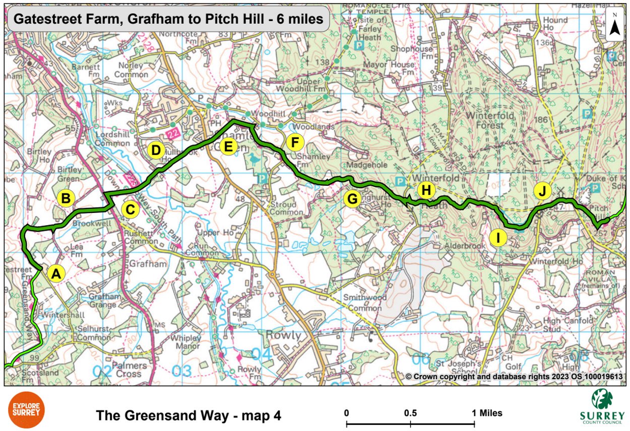
The following letters correspond with the route directions on the map.
A. Turn left along a farm track. Then 275 yards past Keepers follow bridleway to the right of a gate. Continue for half a mile, turning right and then left along a metalled lane.
B. Go ahead over a cattle grid beside Brookwell, then over a stile. Walk ahead along the field edge and to the right of an oak tree. Continue between fences to the road (A281).
C. Cross the road with care, then turn left. Turn right through Rooks Hill Farm. Cross the old railway (Downs Link footpath and bridleway) and the line of the disused Wey and Arun Canal. Continue ahead on a narrow footpath downhill to cross a footbridge. Walk up the slope to the road and cross the road to path opposite and walk to a gate at Long Common.
D. Go through the gateway then ahead between fields. Cross a farm track then walk between fences to the road at Shamley Green. Buses run frequently to Guildford from the village down the hill.
E. Cross the road and walk ahead to the right of the church. Continue through kissing gates to a T-junction. Turn right to a second T-junction. Turn right and walk along the drive to Little Cucknells. Go downhill at the house entrance, keep ahead on the footpath to the road at Stroud Farm.
F. Turn right. After 100 yards walk left along the drive to Shamley Farm. Go through a white gate into a field with the drive on your left. Walk ahead up path between hedges. Take left fork where the fence starts on left, cross a stile and walk uphill through young woodland. At end of woodland pass a large pond by Wilmshurst Farm and go uphill to a stile and T-junction.
G. Turn right. Continue uphill to a fork and walk left uphill through woodland. Keep right to walk along a broad sandy path to the road. Turn left across the road and go up steps to a Hurtwood Control car park.
H. Cross the car park and keep right from the far right-hand corner of it, then follow the track continuing as it narrows. Ignore all side paths. At a T junction, turn left and keep right uphill to join track and turn right. Walk along edge of Hurtwood Control car park no 5 on your left and continue ahead. Cross a drive and go ahead to the road. Turn right and go ahead alongside the road.
I. Just beyond Jelley's Hollow turn right and then left and follow a path uphill parallel to the road until you meet a crossing track very close to the road. Turn right and then almost immediately turn left on a path. Follow this path ignoring side paths until you come to a T-junction. Turn right and follow the main path to the left, continue past a viewing point and then follow the path to Hurtwood Control car park no 4.
J. Cross the car park to the road, turn right to a T-junction and then cross the road. Walk up the track opposite. Pass Ewhurst Cottage, then Ewhurst Windmill on your right. Continue walking to Four Winds and descend a gully to the road. Cross into Hurtwood Control car park no. 3. Turn right and follow the footpath uphill, past a quarry, for 490 yards to the top of Pitch Hill. Make for the viewing platform at the summit that shows landmarks.
What to see
Wey and Arun Canal: The canal left the Wey Navigation at Shalford and rose 48 feet in 6 miles through 7 locks to Cranleigh before descending into West Sussex at Newbridge. Parts of it are being gradually re-opened.
Winterfold Heath: The heath is common land managed by The Hurtwood Control Trust on behalf of the principal owners, the Bray family who were given the land by Henry VII over 500 years ago. In the last century RA Bray, the Lord of the Manor of Shere granted the public a 'right to roam', a pioneering example of a landowner welcoming the public onto his land to walk, ride or cycle.
Jelley's Hollow: Traces of a possible Roman road have been found, running up the hollow towards Winterfold Heath. A road came from Stane Street and passed the site of a Roman temple at Farley Heath.
Ewhurst Windmill: Probably the highest windmill in Surrey, this tower mill was first built in about 1840. Corn-milling ceased here around 1885.
Map 4
Map Four starts at Gate Street Farm, Grafham, crosses the A281 into Rooks Hill Farm until you reach the road and church just outside Shamley Green. The route then goes through parts of Stroud, Shamley and Wilmshurst Farms until you cross over into the Hurtwood Control area of Winterfold Heath. The end of this section climbs Pitch Hill. Select the map of the route below to open a larger version in a new window, that can be printed, if necessary, using your browser print tool with landscape selected. Alternatively, you can save the image to your mobile device, for reference on your walk.