
 The Downs Link footpath and bridleway links the North Downs Way National Trail at St Martha's Hill, Surrey with the South Downs Way near Steyning, West Sussex. For most of its length it follows former railway lines and is popular with cyclists wanting to stay off-road on a well-surfaced track. Please note that the start at St Martha's Hill is steep, uneven and unsurfaced.
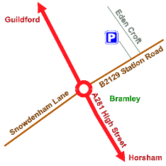
'Easy Going on The Downs Link' is a short walk of about 1 mile in length starting from the car park at the former Bramley Station. The surface is generally firm and level with no steps. There is a short gradient at Tannery Lane Bridge.
Facilities
- unsurfaced path
- parking/blue badge
- trees/woods
- slope (Tannery Lane Bridge)
- grassland
- bridge
- horses/cyclists (mountain bikes advisable due to uneven surface in some areas)
- no toilet facilities
For more information on the Downs Link, see our cycling pages for this and other cycle routes.