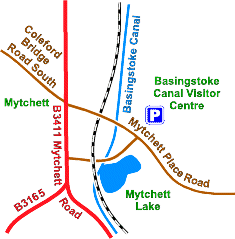
 The Basingstoke Canal runs for 33 miles from Penny Bridge near Odiham, Hampshire to its junction with the River Wey at Woodham. The towpath is level but has steep cambers in places.
A good place to start is from the Basingstoke Canal Visitor Centre which is open all year round. Please ring 01252 370073 for opening times or visit the Canal Authority website.
- toilets/accessible
- parking/blue badge
- unsurfaced path
- trees/woods
- grassland
- refreshments
- take care
- water
- bridge
There is also a flat surfaced trail along the canal towpath through Woking town centre towards St Johns, Woking.
Leaflets available from: The Basingstoke Canal Visitor Centre
Mytchett Place Road
Mytchett
Surrey GU16 6DD
Tel: 01252 370073
Fax: 01252 371758
Email: info@basingstoke-canal.co.uk

