 High resolution coloured digital images of the tithe maps for 103 tithe districts in the present county of Surrey are now available to view in the search room at Surrey History Centre, along with transcripts of the apportionments. Please see Surrey tithe records cds and dvds.
Images of the tithe maps of six districts in Spelthorne which was formerly in Middlesex (Ashford, Laleham, Littleton, Shepperton, Staines and Stanwell) are available to view in the search room at Surrey History Centre, along with transcripts of the apportionments. The original tithe maps and apportionments for Spelthorne are held at The London Archives.
A Surrey-wide database of tithe records is available in the search room at Surrey History Centre.
Surrey History Centre also holds original tithe maps and apportionments for the old county of Surrey, including those parts which are now London boroughs.
The tithe map and apportionment for Dockenfield are held at Hampshire Record Office.
The National Archives holds tithe maps and apportionments for the whole of England and Wales.
Photographic copies of many of the tithe maps and microfilm of the apportionments are also available in the search room at Surrey History Centre, and there is a handlist showing tithe districts, dates and sizes of maps.
Surrey History Centre also holds other material relating to tithes.
The Genealogist website is available to use free of charge at Surrey History Centre. Indexes can be searched for names and keywords, and images of tithe maps and apportionments are available to view.
Tithe commutation
The tithe system
Tithe maps and apportionments were produced as a result of the Tithe Commutation Act 1836. The aim of the Act was to convert traditional tithe payments, which were paid 'in kind' and based on 1/10 of produce, into rent payments which were to be based on the prevailing price of grain.
Tithes were divided into 'great' tithes: corn, grain, hay and wood; and 'small' tithes: all other produce. Usually 'great' tithes were paid to the rector and 'small' tithes to the vicar.
In practice many 'in kind' payments had already been replaced by cash, but before the 1836 Act, theoretically there could always be a reversion to the 'in kind' system.
How was change brought about?
The Enclosure Acts launched the attack on traditional tithe payments. Enclosure frequently involved the allotment of land in place of tithes. Also some proprietors not directly affected by enclosure had tithes commuted under powers given in the Enclosure Acts. The Surrey parishes of Ewell and East Molesey had their tithes extinguished under these Acts.
Tithe questions were debated in parliament between 1828 and 1836. In 1835 Peel's government introduced a Tithe Commutation Bill which included a scheme of payment of corn rents varying with the price of wheat, barley and oats. It did not, however, allow for compulsory commutation as would the final Act.
The Tithe Commutation Act 1836
The Tithe Commutation Act was passed in August 1836 and established three Tithe Commissioners who were based in London. They had the power to confirm voluntary agreements and impose compulsory awards. Most of the work was done by the Assistant Tithe Commissioners whose job was to settle disputes, make agreements and fix awards, in many cases providing a legal framework for what was already established practice.
The Tithe Commissioners divided the country into tithe districts. In many cases the tithe district was the parish and this generally seems to have been the case in Surrey, although there were some exceptions. For example Lambeth was divided into 5 districts and Ewell consisted of Ewell and Kingswood liberty.
There were 150 tithe districts in Surrey, 93% of which were subject to the payment of tithes in 1836. By 1852 the Tithe Commissioners had confirmed apportionments in 139 tithe districts. There were 75 voluntary agreements and 64 compulsory awards.
Procedures for setting tithe payments
Voluntary Agreements were made at a parochial meeting attended by owners of not less than 1/4 of either lands or tithes of the parish. A sum of rent in lieu of tithes agreed by 2/3 of landowners by value and 2/3 of both great and small tithes was binding on the parish if recommended by the Assistant Commissioner.
For Compulsory Awards the Assistant Commissioners ascertained the average value of tithes over the years between 1829 to 1835. If a certain number of landowners complained they had the right to have the award revised by the Assistant Commissioner. A special adjustment could be made in which the tithe values of a parish could be reassessed by comparison with other nearby parishes. There was a special assessment for Shere (reference 361/58/-).
Tithe files held at the National Archives (reference IR18) contain the reports of Assistant Commissioners who conducted the various meetings in the district and, where one was made, the draft of the award.
Surrey History Centre holds some material relating to the process of tithe commutation under the Act. Charlwood parish (reference 248/13/-) where an agreement on commutation was reached includes printed matter prepared by the Assistant Commissioner using standard procedures. There is material relating to various parochial meetings, and correspondence including a letter from Robert Lewin offering to carry out mapping, surveying and apportionment of the parish for the sum of 1s 3d per acre.
Surrey History Centre also has material relating to Little Bookham (reference 181/12/-) and Chobham (reference 361/2/-).
Tithe apportionments
Tithe apportionments follow a standard pattern.
First, the substance of the preceding agreement or award was recited in the preamble of the instrument of apportionment. The Charlwood tithe apportionment is an example of an agreement. It confirms an agreement made at a meeting held in the parish 26 May 1838 that the sum of £905 rent charge was to be paid to the rector in place of tithes (reference 865/1/4). The Hambledon tithe apportionment is an example of an award. The Assistant Tithe Commissioner Thomas James Tatham, who identified himself as a land agent, awarded the sum of £243 10s to be paid to the rector in place of tithes (reference 864/1/78).
An estimate was then recorded of the acreage of the parish and categories of tithable land according to the state of cultivation.
Next a valuation was given. Rent-charge was expressed as a corn rent: a sum which would, if divided into three equal parts, have purchased the same quantity of wheat, barley and oats as the tithe produced in 1836.
This is followed by the portions of the rent-charge to be paid by each landowner, generally arranged in alphabetical order by landowner.
There were columns for:
- Name of landowner(s)
- Name of occupier(s)
- Number (on tithe map)
- Acreage
- Name or description and state of cultivation of each tithe area or description of premises (arable, meadow, pasture, coppice, hop-ground, market garden, Common, house and garden)
- Amount of rent-charge payable
- Name of tithe owner(s)
Sometimes both 'inbound' and 'outbound' acreages are given. 'Outbound' acreage was the total area including wooded areas, hedges and ditches; whilst 'inbound' acreage was the area which could be cultivated. The Chiddingfold apportionment is a Surrey example of this practice, which was common in Sussex. On the Chiddingfold tithe map, wooded areas are coloured blue.
The tithe apportionment was originally bound together with the tithe map.
Tithe maps
Tithe maps are important as the first systematic mapping survey of most of the land in England and Wales, as compared to estate maps which were for limited private use. They were made before the Ordnance Survey produced the large scale 25 inch to the mile series of maps.
Parish boundaries in southern England may reflect not only the boundaries of very old ecclesiastical units but possibly even older estate boundaries. Tithe maps can show an 'island' of one parish inside another, which may reflect a division between two estates. These 'islands' were assimilated into the surrounding parishes in the 19th century and so may have disappeared before the first series Ordnance Survey maps were surveyed. The Hambledon tithe map (reference 864/1/77) is an example.
Tithe field numbers may be found identifying areas of land on 19th century title deeds.
In contrast to the general uniformity of tithe apportionments, tithe maps vary greatly in accuracy, scale and size.
The landowners were responsible for paying for both the tithe map and the apportionment, and as plotting each new map on a standard scale was expensive, the Tithe Amendment Act 1837 allowed for two grades of map.
First-class maps were deemed to be accurate for legal purposes and were sealed by the Tithe Commissioners. Second-class maps were satisfactory as long as they were acceptable to 3/4 of landowners and presented the information on tithe areas correctly, while corresponding with the apportionment.
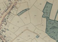
The colour pink on tithe maps is used to indicate an inhabited building. Outbuildings are coloured grey.
Scales of Surrey tithe maps vary between 1.5 and 12 chains to 1 inch, with about 68% within the recommended scale range of between 3 to 4 chains to 1 inch. (20 chains equals 1/4 mile)
The legislation stipulated that after the map and apportionment had been ratified by the Tithe Commissioners they would be displayed in the parish. They would then be returned, so that two further copies could be made, one for the diocesan registry and one for the incumbent of the parish. The Public Record Office has a complete set of the Commissioners' maps. The diocesan and parish copies are likely to be found in local record offices.
Gaps in coverage
Lands previously exonerated from tithe by enclosure were usually not surveyed.
Some land had never been titheable, such as land which belonged to certain religious houses. Examples in Surrey are: Wanborough, St Mary Bermondsey, Churt - a perpetual curacy, St Peter Newington - a district chapelry.
Non-titheable land deemed to be unproductive could be excluded; commons and roads were also excluded.
All woodland in the weald in Surrey, Sussex and Kent was tithe free.
Variations in quality and scale
In Surrey 32% of tithe maps are sealed as first-class, and these seem to be concentrated in a west-east band along the North Downs. The tithe maps of Croydon, Dorking and Epsom are unusual in being first-class maps of urban areas.
Second-class maps are extremely variable in quality. Some were original surveys, others little more than topographical sketches or copies of slightly earlier maps. Some made elaborate use of colour to distinguish different properties, tithe free areas or land use, while others gave no such detail. With second-class maps the date of the survey is usually uncertain. In Surrey the tithe map of Lingfield is a copy of an 1816 map and the tithe map of Wimbledon is a copy of an 1838 map.
Even amongst first-class maps there is a great deal of variation in scale and content. Significant variations have been shown between different versions of the same map.
Further reading about tithes and tithe maps
- Tate, W.E. The parish chest: a study of the records of parochial administration. Cambridge University Press, 1983. Background information.
- Harley, J.B. Maps for the local historian: a guide to the British sources. National Council for Social Service, 1972. Basic details on tithe maps.
- Evans, E.J. and Crosby A.G. Tithes: maps, apportionments and the 1836 Act: a guide for local historians. 3rd edition, British Association for Local History, 1997. A good brief account.
- Riden, P. Local History: a handbook for beginners. Batsford, 1998. Use of tithe maps for researchers.
- Kain, R.J.P. and Oliver, R.R. The tithe maps of England and Wales: a cartographic analysis and county by county catalogue. Cambridge University Press, 1995. Detailed information.
- Kain, R and Wilmot, S. Tithe surveys in national and local archives in Archives, Volume XX (20) Number 87 pp 106-117. Survey on the variations between maps.