What is the Waverley LCWIP?
The Waverley Local Cycling and Walking Infrastructure Plan (LCWIP) is a ten-year investment plan for walking and cycling in the borough. It identifies where we want to prioritise investment and sets out some initial options and ideas for improving walking and cycling across the borough.
LCWIPs are the best practice approach nationally for planning walking and cycling improvements and our process follows Department for Transport guidance. To find out more about LCWIPs, including what they are and the process that we have followed to develop LCWIPs for the county, please see our plans to improve cycling and walking page.
The Waverley LCWIP focuses on strategic network connections and aims to create a wider walking and cycling network for the borough. Local neighbourhood and street level interventions are not included within the LCWIP and will be part of separate workstreams that aim to improve walking and cycling provision at smaller scales. For example, we aim to develop 'Liveable Neighbourhood' schemes to increase the comfort, safety and accessibility of walking and cycling on residential roads by recognising the importance of these streets as places for people, and not just their importance for the movement of vehicles. 'Liveable Neighbourhoods' will create attractive local environments that connect residents to the wider LCWIP network and make walking and cycling easier, safer, more enjoyable, convenient, and fun for everyone. To find out more about our plans for walking and cycling at the street and neighbourhood scale, please see our Local Transport Plan policies for Planning for Place and for Active Travel and Personal Mobility.
If you would like to view the Waverley LCWIP report in full, please email surreytransportplan@surreycc.gov.uk to request a copy.
Executive summary
The Waverley LCWIP's key proposals are cycling routes and walking zones, which together create a walking and cycling network for the borough.
All cycling routes and walking zones identified in the LCWIP have been designated as either Phase 1, 2 or 3. This helps to prioritise investment over the LCWIP's ten-year lifespan. Phase 1 routes and zones are those that we aim to implement in the short-term (1 to 3 years), whilst we aim to implement Phase 2 routes and zones over the medium-term (3 to 7 years), and Phase 3 routes and zones in the longer term (7+ years). Prioritisation of the routes and zones is based on a number of factors, including:
- Present and future demand for the route, including local stakeholder input, road traffic collision data and projected usage.
- The quality that improvements will deliver compared to the provision that currently exists.
- How the route or zone will contribute to increased access for walking and cycling to key destinations such as schools, doctors' surgeries, hospitals, rail and bus stations, high streets, and parks
The full LCWIP report includes network maps that show the locations of all of the cycling routes and walking zones. It also includes initial concept ideas for the Phase 1 routes and zones and explains and lists the full prioritisation programme of all of the different cycling routes and core walking zones.
The LCWIP has considered the full extent of the borough, with an emphasis on key trip attractors and destinations that will encourage and allow more people to take up walking and cycling as their everyday types of travel.
Cycling network
Phase 1 cycling routes
Godalming
This cycle route is a loop around Godalming, connecting to Holloway Hill and Farncombe and serving Godalming Railway Station and a series of education facilities.
This route is mainly on-road but includes sections of segregation for cyclists and proposes a number of parallel crossings and junction modifications to improve levels of safety.
This route is approximately 10 kilometres in length.
Milford to Witley Railway Station
This cycle route starts at Godalming College and ends at Witley Railway Station, extending along Portsmouth Road. It looks to connect Holloway Hill, Milford, Witley and Wormley as well as serving multiple education facilities.
This corridor shows high potential for a further increase of cycling and with several developments planned along the corridor, this is likely to increase further.
Much of the proposed route uses shared paths and segregated cycle tracks. Alternative alignments to Portsmouth Road and Petworth Road are planned to be developed for less confident cyclists that may not be as direct but are away from high traffic flows.
Approximate length: 8.5 kilometres.
Cranleigh
This route extends around and through Cranleigh, connecting to various destinations including Cranleigh School. It also provides a link to National Cycle Network (NCN) Route 223.
The proposals include segregated cycle facilities along Guildford Road and High Street (B2128) and improvements to the access points to the NCN Route 223 as well as additional signage.
This route is approximately 5.8 kilometres in length.
Haslemere
This route provides a local network within Haslemere starting at Woolmer Hill School and ending at the High St junction with Church Lane. It connects strategic destinations in the area including Haslemere Railway Station, Haslemere and District Hospital, The Edge leisure centre, commercial areas, and several schools.
The route is approximately 8.5 kilometres in length.
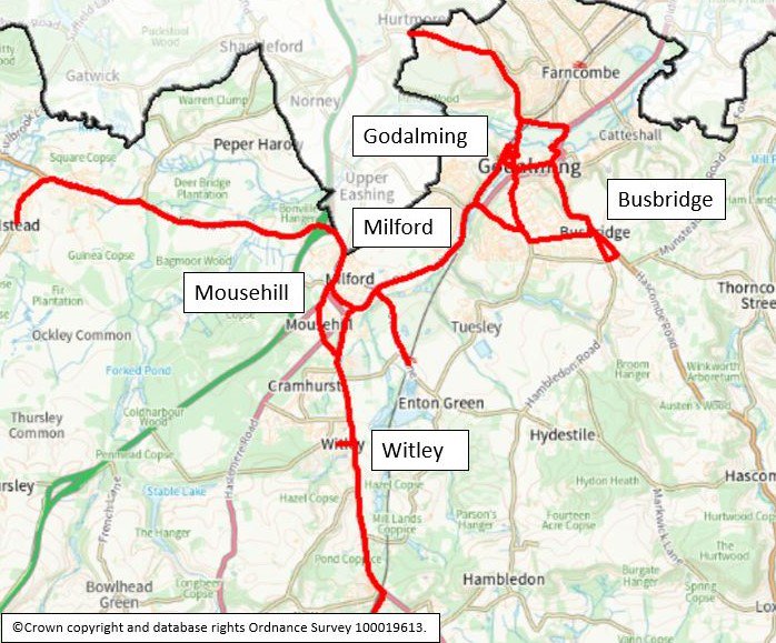
Map 1: Phase 1 cycle routes in Godalming, Milford and Elstead
The below map image shows the extent of the cycle routes in Godalming, Milford and Elstead that have been prioritised in the Runnymede LCWIP (Godalming town centre, Elstead to Milford and Milford to Witley Railway Station).
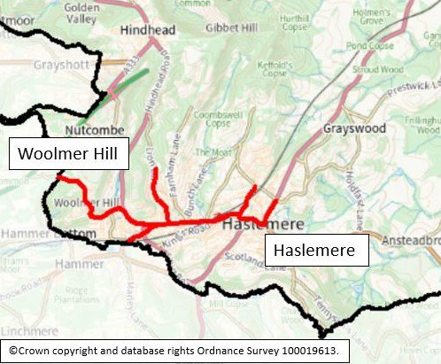
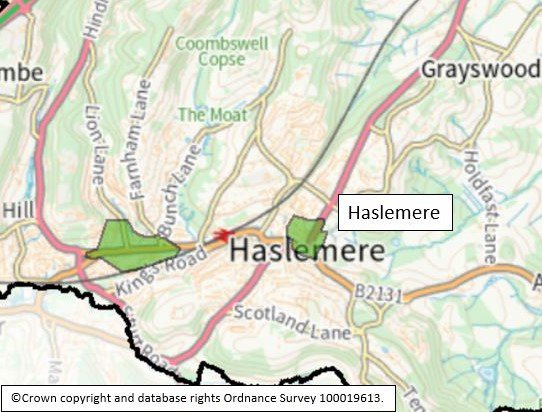
Map 2: Phase 1 cycle routes in Haslemere
The below map image shows the extent of the cycle route in Haslemere that has been prioritised in the Runnymede LCWIP (which runs from Woolmer Hill School to The High Street).
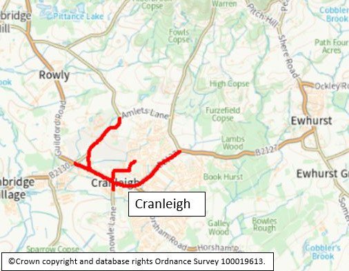
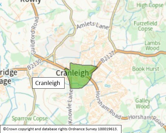
Map 3: Phase 1 cycle routes in Cranleigh
The below map image shows the extent of the cycle route in Cranleigh that has been prioritised in the Runnymede LCWIP (which runs along Guildford Road, The High Street and Ewhurst Road).
Phase 2 and 3 cycling routes
- Farncombe. This forms a route around Farncombe connecting to Farncombe Railway Station and serving a series of education facilities. Approximate length: 5.7 kilometres.
- Holloway Hill to Enton Green. This route connects Holloway Hill to Milford Railway Station and to Enton Green, starting at Godalming College and ending at RodBorough Technical College. Approximate length: 4.3 kilometres.
- Bramley to Godalming. This route connects Bramley to Farncombe, Catteshall and Godalming, starting at St Catherine's School and ending near Godalming High Street. Approximate length: 4.7 kilometres.
- Wonersh to Shamley Green. This route connects Shalford, Wonersh and Shamley Green, serving several education facilities. Approximate length: 7.2 kilometres.
- NCN Route 223 Bramley to Cranleigh. This is the existing NCN Route 223 along an off-carriageway path, connecting Shalford and Cranleigh through Bramley. Approximate length: 10.9 kilometres.
- Cranleigh to Ewhurst. This route links Cranleigh to Ewhurst, following the B2127 along the existing cycle facilities. Approximate length: 3.4 kilometres.
- Cranleigh to Alford. This route connects Cranleigh to Alford, along on-road and off-carriageway sections as well as providing a link to Dunsfold Park Garden Village Development and NCN Route 223. Approximate length: 6.4 kilometres.
- Dunsfold Park Garden Village Development. This route will provide connections from Dunsfold and Alford to the Garden Village Development as well as linking with the development's proposed cycle corridor. Approximate length: 5.4 kilometres.
- Dunsfold to Witley. This route connects Dunsfold to Witley Railway Station, serving Hambledon using both on-road and off-carriageway facilities. Approximate length: 8.6 kilometres.
- Witley to Chiddingfold. This route connects Witley and Chiddingfold using largely off-carriageway paths, extending between Witley Railway Station and St Mary's CofE Primary School. Approximate length: 3.3 kilometres.
- Chiddingfold to Haslemere. This route serves a series of education facilities and connects Chiddingfold to Grayswood and Haslemere. Approximate length: 7.9 kilometres.
- Hindhead to Haslemere. This route extends to Grayshott, connecting Hindhead and Haslemere and serves Amesbury School, The Royal Junior School, and St Edmunds School. Approximate length: 4.1 kilometres.
- Milford to Hindhead. This route uses primarily off-carriageway paths to connect Milford to Hindhead, serving Devil's Punchbowl and Hindhead Common National Trust. Approximate length: 10.6 kilometres.
- Thursley to Witley. This route connects Thursley and Witley on on-road and off-carriageway facilities. Approximate length: 7.1 kilometres.
- Elstead to Milford. This route connects Elstead to Milford via the B3001 Milford Road and Elstead Road and serves St James C of E Primary School and Milford School. Approximate length: 7.3 kilometres.
- Elstead to Farnham. This route connects Elstead to Farnham, linking to the Farnham Town LCWIP aspirational network via Waverley Lane and serving several education facilities using on-road and off-road sections. Approximate length: 9.1 kilometres.
- Tilford to Farnham. This route connects Tilford to Farnham following Tilford Road. It serves All Saints C of E Aided Infant School and links to Farnham Town LCWIP aspirational network at Monks Walk. Approximate length: 2.9 kilometres.
- Tilford to Hindhead. This corridor connects Tilford and Hindhead via Beacon Hill. Approximate length: 8.3 kilometres.
- Churt to Farnham. This route connects Churt to Farnham via Frensham and Shortfield Common, serving a series of education facilities. It will provide a connection to the Farnham Town LCWIP aspirational network via the A287. Approximate length: 11.2 kilometres.
- Shamley Green to Rowly. This route connects Shamley Green, Rowly and Cranleigh, along the B2128 Church Hill and Guildford Road. The route is parallel to the NCN Route 223 and serves the Manfield Park business estate. Approximate length: 5.2 kilometres.
Walking network
Phase 1 core walking zones
Godalming Town Centre
This zone covers Godalming Railway Station and multiple roads leading up to this, as well as the High Street, The Burys, Bridge Street, and sections of Flambard Way and Catteshall Lane. This is in close proximity with the Farncombe core walking zone.
Wey Hill and Lion Green
This zone covers the area around Liphook Road and Wey Hill, Wey Springs, and Lion Lane. Proposals include a number of junction and crossing improvements, enhancing the environment for walking and cycling.
Haslemere High Street
This zone covers the southern section of the High Street and the junction with Lower Street and Petworth Road, and West Street in the town of Haslemere. Destinations within a 10-minute walk around the zone include Haslemere Railway Station, Haslemere Community Hospital and High Lane Community Centre.
Proposals include sections of new footway, new signage, junction improvements and new and upgraded crossing points.
Cranleigh
This zone covers a section of the High Street, Ewhurst Road, Horsham Road, and other roads in the village of Cranleigh. Destinations within a ten-minute walk around the zone include Cranleigh Community Hospital, several educational facilities, and Cranleigh Library.
12 pedestrian collisions have been recorded within the zone.
Farncombe
This zone covers Farncombe Railway Station area and the roads leading up to this including Farncombe Street, Summers Road, and Lower Manor Road. Destinations within a ten-minute walk around the zone include Farncombe Railway Station, several educational facilities and a number of other destinations including Godalming Leisure Centre.
Six pedestrian collisions have been recorded within the zone.
Proposals include new and widened footways, raised tables at junctions, new and upgraded crossings and signage.
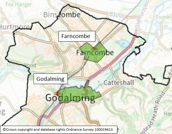
Map 4: Phase 1 walking zones in Godalming and Farncombe
The below map image shows the extent of the Core Walking Zones in Godalming and Farncombe that have been prioritised in the Runnymede LCWIP. The Godalming CWZ extends along the High Street, from Godalming Railway Station in the west to Sainsbury's Supermarket in the east.
Map 5: Phase 1 walking zone in Haslemere and Wey Hill and Lion Green
The below map image shows the extent of the Core Walking Zone in Haslemere that has been prioritised in the Runnymede LCWIP. The Wey Hill CWZ extends along the retail area of Haslemere. The Haslemere High Street CWZ covers the area around the Haslemere retail centre located along and to the west of High Street.
Map 6: Phase 1 walking zones in Cranleigh
The below map image shows the extent of the Core Walking Zone in Cranleigh that has been prioritised in the Runnymede LCWIP which covers Cranleigh High Street and the large residential area to the south.
Phase 2 and 3 Core Walking Zones
- Bramley and Wonersh. This zone covers the High Street, Station Road, Barton Road and Linersh Road in Bramley as well as The Street, Wonersh Common and Barnett Lane in Wonersh.
- Hindhead. This zone covers the crossroads where Portsmouth Road, Tilford Road, Hindhead Road and London Road intersect with Hindhead. Destinations within a 10-minute walk include St Edmund's School and the Devil's Punchbowl.
- Beacon Hill. Beacon Hill Road, Parsons Lane and Churt Road are covered by this zone. It is in close proximity with the Hindhead CWZ.
- Grayswood. This zone covers the junction between the A286 Grayswood Road and Lower Road with Grayswood Primary School within a ten-minute walk of the zone.
- Milford. This zone covers a loop between Portsmouth Road, Church Road and Cherry Tree Road, alongside other roads in the village of Milford. Over 370 new dwellings are proposed within a ten-minute walk of the zone.
- Alfold. This zone covers a section of the B2133 Loxwood Road, where it intersects with Rosemary Lane in Alford.
- Ewhurst. The Street and The Mount are covered by this zone, with Ewhurst Infants School and Sayers Croft Outdoor Learning Centre within a ten-minute walk.
- Dunsfold. This zone covers a section of Dunsfold Common Road and is in close proximity to the Dunsfold Park Garden Village CWZ.
- Elstead. This zone covers the Thursley Road intersection with the B3001 and Farnham Road and Milford Road in Elstead. 3 pedestrian collisions have been recorded within the zone.
- Witley. This zone covers a section of Petworth Road and Church Lane in Witley. Destinations within a ten-minute walk include Witley C of E Infant School, The Chandler C of E School, Barrow Hills School and Witley Play Park.
- Witley Wheeler Street. This zone overlaps with the Witley CWZ and covers Petworth Road and a section of Wheeler Lane and Roke Lane. Destinations within a ten-minute walk include Rodborough Technology College.
- Tilford. This zone covers the intersection between Tilford Road and Tilford Street, with Tilford Green in the centre.
- Shortfield Common. This zone covers a section of Shortfield Common Road and its intersection with the A287 Frensham Road and Hollowdene Recreation Ground. Destinations within a ten-minute walk include Frensham Church and Moor House School.
- Chiddingfold. This zone covers a section of the A283 Petworth Road and its intersection with The Green and Pickhurst Road, as well as other roads in the village of Chiddingfold.
- Dunsfold Park Garden Village. Dunsfold Park and Dunsfold Aerodrome are covered by this zone. It is in close proximity to the planned Dunsfold CWZ.
- Churt. This zone covers a section of the Crossways and A287 and its intersections with both Old Kiln Lane and Hale House Lane in Churt.
- Shamley Green. This zone covers a section of the B2128 Guildford Road and Hillbrook Lane, with Wonersh and Shamley Green Primary School and Longacre School within a ten-minute walk of the zone.
- Hambledon. This zone covers sections of Malthouse Lane and Vann Lane and junction between these roads in the village of Hambledon.
- Witley Railway Station. Witley Railway Station, King Edward's School and Coopers Place Business Park are all within a ten-minute walk of this zone which covers the Station and roads leading up to it, including Robin Way, Combe Lane, Brook Road, Station Lane and a section of Petworth Road.
Next steps
The Waverley report should be used to support the case for further stages of design, assessment, and stakeholder engagement, and to secure funding to progress improvements for the routes identified by the report. Because the LCWIP is intended to facilitate a long-term approach to developing active travel proposals, over a period of approximately 10 years, all of the corridors identified within the active travel network maps are recommended for further consideration at an appropriate time.
The next stage of implementing the Waverley will be to further develop the design concepts for the Phase 1 cycling and walking routes into a feasibility level of design and assessment. This will include full public consultation, allowing residents and other local stakeholders to have their say on the individual scheme proposals.
The LCWIP will be reviewed and updated periodically, particularly in response to significant changes in local circumstances such as the publication of new policies or strategies.
If you wish to view the full Waverley LCWIP report, please email surreytransportplan@surreycc.gov.uk requesting a copy.
