What is the Runnymede Local Cycling and Walking Infrastructure Plan?
The Runnymede Local Cycling and Walking Infrastructure Plan (LCWIP) is a ten-year investment plan for walking and cycling in the borough. It identifies where we want to prioritise investment and sets out some initial options and ideas for improving walking and cycling across the borough.
LCWIPs are the best practice approach nationally for planning walking and cycling improvements and our process follows Department for Transport guidance. To find out more about LCWIPs, including what they are and the process that we have followed to develop LCWIPs for the county, please see our plans to improve cycling and walking page.
The LCWIP focuses on strategic network connections and aims to create a wider walking and cycling network for the borough. Local neighbourhood and street level interventions are not included within the LCWIP and will be part of separate workstreams that aim to improve walking and cycling provision at smaller scales. For example, we aim to develop 'Liveable Neighbourhood' schemes to increase the comfort, safety and accessibility of walking and cycling on residential roads by recognising the importance of these streets as places for people, and not just their importance for the movement of vehicles. 'Liveable Neighbourhoods' will create attractive local environments that connect residents to the wider LCWIP network and make walking and cycling easier, safer, more enjoyable, convenient, and fun for everyone. To find out more about our plans for walking and cycling at the street and neighbourhood scale, please see our Local Transport Plan policies for Planning for Place and for Active Travel and Personal Mobility.
If you would like to view the Runnymede LCWIP report in full, please email surreytransportplan@surreycc.gov.uk to request a copy.
Executive summary
The Runnymede LCWIP's key proposals are cycling routes and walking zones, which together create a walking and cycling network for the borough.
All cycling routes and walking zones identified in the LCWIP have been designated as either Phase 1, 2 or 3. This helps to prioritise investment over the LCWIP's ten-year lifespan. Phase 1 routes and zones are those that we aim to implement in the short-term, whilst we aim to implement Phase 2 routes and zones over the medium-term, and Phase 3 routes and zones in the longer term. Prioritisation of the routes and zones is based on a number of factors, including:
- Present and future demand for the route, including local stakeholder input, road traffic collision data and projected usage.
- The quality that improvements will deliver compared to the provision that currently exists.
- How the route or zone will contribute to increased access for walking and cycling to key destinations such as schools, doctors' surgeries, hospitals, rail and bus stations, high streets, and parks
The full LCWIP report includes network maps that show the locations of all of the cycling routes and walking zones. It also includes initial concept ideas for the Phase 1 routes and zones and explains and lists the full prioritisation programme of all of the different cycling routes and core walking zones.
The LCWIP has considered the full extent of the borough, with an emphasis on key trip attractors and destinations that will encourage and allow more people to take up walking and cycling as their everyday modes of transport.
Cycling network
Phase 1 cycling routes
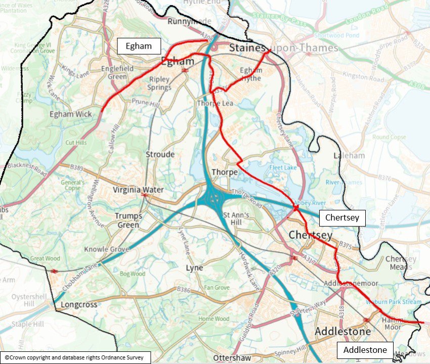
Thorpe Road / Chertsey to Egham
This route serves both Chertsey and Egham town centres, upgrading current provision in the town centres as well as connecting the areas with each other and local residential areas.
Egham and Chertsey are within ideal cycling distance of each other, with only slight gradients on the route between them. Data analysis shows a very high potential for cycling between these locations. The route has a number of alternative alignments which will be explored further during feasibility. The approximate length of the route is 8 kilometres.
Weybridge Road
Running from Chertsey to Weybridge town centre, northeast of Addlestone, this route serves a large number of destinations including Saint George's College and Bourne and Weybridge Business Parks. This approximate length of this route is 3 kilometres.
The route looks to upgrade existing low-quality cycle facilities and implement new ones where possible, enabling safer travel to Weybridge station which has frequent connections to London and other destinations in Surrey. Two potential alignments are proposed via existing facilities or off-carriageway paths, these will be explored further as part of the feasibility study.
Egham to Virginia Water via the A30
This route connects Egham to Virginia Water via the A30, linking to key employment centres such as Royal Holloway University and Egham International School. The route is approximately 8.5km in length, with one-way or two-way segregated cycle tracks proposed along the entire route.
This route records a high number of cycle trips and shows high potential for a further increase of cycling by up to 5 times the current usage.
Thorpe Lea Road / Thorpe Road
This route extends from Staines Bridge to Thorpe Lea Road, where, at present, cycle provision is narrow and inconsistent. The route seeks to provide a safe connection through a mixture of land uses including: schools, local shops and residential areas.
It is an important local corridor linking Thorpe Industrial Estate to Staines Railway Station, which has frequent connections to London and therefore has a high potential for an increase of cyclists.
Phase 1 Cycling Routes map
The below map image shows the extent of the four cycling routes that have been prioritised in the Runnymede LCWIP (Chertsey to Egham, Weybridge Road, Egham to Virginia Water and Thorpe Lea Road).
Phase 2 and 3 cycling routes
- Chertsey Bridge. This route links Chertsey town centre with a number of residential areas. Approximate length: 2 kilometres.
- Guildford Road/A320. This route looks to improve the connection between Chertsey, St Peter's Hospital, Ottershaw and Woking. Approximate length: 5 kilometres.
- Woodham Lane/B385. This route will serve the Broadway Shopping Centre and the Animal and Plant Health Agency with potential for links to Byfleet and New Haw and West Byfleet Railway Stations. Approximate length: 3 kilometres.
- New Haw Road/A318. This route will link Addlestone town centre with Byfleet and New Haw Railway Station as an alternative to Weybridge Road. Approximate length: 4 kilometres.
- Woodhatch to East Surrey Hospital. The route connects the residential area on the southern side of Reigate to East Surrey Hospital, via Three Arch Road.
- Norlands Lane/Christchurch Road. This route provides an east-west connection between Chertsey Lane and Virginia Water Lake. It is an alternative, flat alignment to the A30 via quiet residential streets.
- Green Lane/Hardwick Lane. This route provides a connection between Addlestone and the extension of Chertsey Lane – Staines Road. It also connects to new development Chertsey Bittams and St Peter's Hospital.
- Staines Road/A320. This route is the main north-south corridor used by cyclists in the Borough and improvements are needed to make this a safe connection for all.
- St Ann's Road. This route is a key link between Staines Road and Chertsey town centre. It offers a quieter, parallel alignment to the A317.
- St Jude's Road. This route looks to improve the connection between the A30 and Windsor Road via Englefield Green, linking to Royal Holloway University and development sites in the area.
- Spinny Hill/Church Road. This route would serve Addlestone town centre as well as providing access to Addlestone Railway Station for the residential areas west of the M25.
- Middle Hill. This is the most direct route between Englefield Green and Egham and acts as an important commuter corridor for Englefield Green residents, for those working in Egham, or travelling to other destinations via Egham Railway Station.
- Windsor Road. This route can serve both commuter and leisure trips along Runnymede Meadows, parallel to the River Thames. It links Runnymede with Windsor and Maidenhead Borough.
- Longcross Road/Holloway Hill. This route will link to secondary schools in Chertsey, St Peter's Hospital, and business parks in Addlestone and Chertsey. It will also serve future commuter trips created by the Longcross Garden Village development.
- Egham/Station Road. This route extends south of Egham Town Centre and links the commercial area, the railway station, Manorcroft Primary School and the leisure centre on Vicarage Road.
- Stroude Road/Longcross. This route will serve future and existing commuter trips between Longcross Garden Village development, Virginia Water and Egham, linking the railway stations, Royal Holloway University, secondary schools and the college.
Walking network
Phase 1 core walking zones
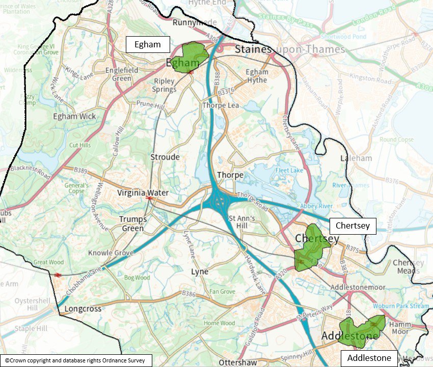
Egham Core Walking Zone
This zone extends around the commercial centre of Egham Town and aims to improve access to key destinations such as Strode's College and Egham Railway Station. It will also serve trips between the residential areas and the schools in Thorpe and Egham Town.
Egham-by-Pass, Egham Hill and Vicarage Road were selected as supplementary walking corridors to improve hostile pedestrian environments.
Chertsey Core Walking Zone
This zone extends between Staines Road, the M3, St Peter's Way, and the M25. It has a mix of land uses: commercial activity, residential areas, a business park, green spaces, railway station, and schools and the zone improvements aim to improve access to these.
Proposals include new and upgraded crossings, footway widening and resurfacing and new wayfinding signage.
Addlestone Core Walking Zone
This zone includes the commercial and residential areas of Addlestone and seeks to improve connections to local shops, schools, and the railway station. Proposals include widening the footways on Station Road, upgrading, and adding new crossings and adding wayfinding signage.
A supplementary walking corridor is proposed to link Addlestone town centre to the Business Parks, which continues to Weybridge town centre. This will serve both towns and link them together via quiet roads parallel to the busy Weybridge Road.
Phase 1 Core Walking Zones map
The below map image shows the extent of the three core walking zones that have been prioritised in the Runnymede LCWIP (Egham, Chertsey and Addlestone).
Phase 2 and 3 Walking Zones
- Englefield Green core walking zone. This extends along St Jude's Road and serves the residential area, local schools and the university.
- Staines core walking zone. This zone runs along The Causeway, Thorpe Road and towards Staines. Additional walking corridors are proposed to connect the zone with the business parks and Egham Town.
- Thorpe Lea core walking zone. This zone extends on Thorpe Lea Road and Pooley Green Road, in an area that includes two schools, a commercial area and residential streets.
- Virginia Water core walking zone. This extends along the commercial area in Virginia Water, close to the railway station and looks to tackle the significant number of short car trips in the area.
- Ottershaw core walking zone. This zone extends around the Guildford Road/Chobham Road roundabout. Both of these roads currently create a barrier for pedestrians.
- Woodham/New Haw core walking zone. There are a high number of short car trips in this area so this zone looks to connect the commercial centre with residential areas, Byfleet and New Haw railway station and areas of employment.
- Royal Holloway core walking zone. Egham Hill is the key corridor in this zone with the main entrances to the university and student accommodation located there. It also extends to Egham Town and Englefield Green, helping with short trips to the commercial areas, Egham Railway Station and residential areas.
Next steps
The Runnymede report should be used to support the case for further stages of design, assessment, and stakeholder engagement, and to secure funding to progress improvements for the routes identified by the report. Because the LCWIP is intended to facilitate a long-term approach to developing active travel proposals, over a period of approximately 10 years, all of the corridors identified within the active travel network maps are recommended for further consideration at an appropriate time.
The next stage of implementing the Runnymede will be to further develop the design concepts for the Phase 1 cycling and walking routes into a feasibility level of design and assessment. This will include full public consultation, allowing residents and other local stakeholders to have their say on the individual scheme proposals.
The LCWIP will be reviewed and updated periodically, particularly in response to significant changes in local circumstances such as the publication of new policies or strategies.
If you wish to view the full Runnymede LCWIP report, please email surreytransportplan@surreycc.gov.uk requesting a copy.
