What is the Elmbridge LCWIP?
The Elmbridge Local Cycling and Walking Infrastructure Plan (LCWIP) is a ten-year investment plan for walking and cycling in the borough. It identifies where we want to prioritise investment and sets out some initial options and ideas for improving walking and cycling across the borough.
LCWIPs are the best practice approach nationally for planning walking and cycling improvements and our process follows Department for Transport guidance for planning local cycling and walking networks (GOV.UK)
To find out more about LCWIPs, including what they are and the process that we have followed to develop LCWIPs for the county, please see our: Plans to improve walking and cycling webpage.
The LCWIP focuses on strategic network connections and aims to create a wider walking and cycling network for the borough. Local neighbourhood and street level interventions are not included within the LCWIP and will be part of separate workstreams that aim to improve walking and cycling provision at smaller scales. For example, we aim to develop 'Liveable Neighbourhood' schemes to increase the comfort, safety and accessibility of walking and cycling on residential roads by recognising the importance of these streets as places for people, and not just their importance for the movement of vehicles. 'Liveable Neighbourhoods' will create attractive local environments that connect residents to the wider LCWIP network and make walking and cycling easier, safer, more enjoyable, convenient, and fun for everyone.
To find out more about our plans for walking and cycling at the street and neighbourhood scale, please see our Local Transport Plan policies for Planning for Place and for Active travel and personal mobility.
If you would like to view the Elmbridge LCWIP report in full, please email surreytransportplan@surreycc.gov.uk to request a copy or see below for a summary of the report.
Executive summary
The Elmbridge LCWIP's key proposals are cycling and walking routes, which together create a walking and cycling network for the borough. These proposals are outlined below.
All cycling and walking routes identified in the LCWIP have been designated as either Phase 1, 2 or 3. This helps to prioritise investment over the LCWIP's ten-year lifespan. Phase 1 routes are those that we aim to implement in the short-term, whilst we aim to implement Phase 2 routes over the medium-term, and Phase 3 routes in the longer term. Prioritisation of the routes and corridors is based on a number of factors, including:
- Present and future demand for the route, including local stakeholder input, road traffic collision data and projected usage
- The quality that improvements will deliver compared to the provision that currently exists on the route
- How the route will contribute to increased access for walking and cycling to key destinations such as schools, doctors' surgeries, hospitals, rail and bus stations, high streets, and parks
The full LCWIP report includes network maps that show the locations of all the cycling and walking routes. It also includes initial concept ideas for the Phase 1 routes and explains and lists the full prioritisation programme of all the different cycling and walking routes.
The LCWIP has considered the full extent of the borough, with an emphasis on key trip attractors and destinations that will encourage and allow more people to start walking and cycling as their everyday mode of transport.
Cycling network
Phase 1 cycling routes
Esther Road, Queensway, and Queens Road
This strategic east/west route connects Esher Town Centre and Hersham village and connects to onward linkages towards Walton-on-Thames and Weybridge. The route will provide a new facility on Lammas Lane and improve the existing facility on the River Mole crossing and Esher Road.
It is an important link for multiple railway stations, schools and employment sites which are near the corridor. The approximate length of this route is 4.5 kilometres.
Hersham Road
This route provides the most direct alignment linking Hersham village and Walton Town Centre. It also supports onward journeys to Spelthorne via the Thames crossing in Walton (though not part of the corridor itself).
There are no existing cycle facilities in this corridor, so this route will improve access to Walton Station, local commercial areas, and multiple schools (including Three Rivers Academy) by cycle. The approximate length of this route is 2.3 kilometres.
Walton-Molesey Link via Hurst Road and Terrace Road
This route provides a strategic, direct connection between Walton Town Centre, Molesey, and Hampton Court. It will provide a high-quality, safe cycle facility on a route where there is currently inconsistent or non-existent cycle facilities, and a high number of cycle collisions have occurred.
The route is approximately 7.3 kilometres, providing valuable access to several schools, local commercial areas, Hampton Court Station and two Thames crossings.
Portsmouth Road North
This strategic east/west route connects Esher Town Centre and Surbiton and Kingston, providing continuity of the existing cycle route along the A307 in Kingston.
Although there are existing advisory cycle lanes along sections of the route, there have been a high number of cycle collisions. Consequently, improvements will seek to provide a high-quality, safe cycle link. The approximate length of this route is 4.6 kilometres.
Hampton Court Way
This strategic north/south network link will provide an upgraded facility alongside A309 Hampton Court Way and connect Hampton Court to the Portsmouth Road corridor, as well as proposed cycle facilities along the Kingston Bypass to Hinchley Wood. The approximate length of this route is 2.6 kilometres.
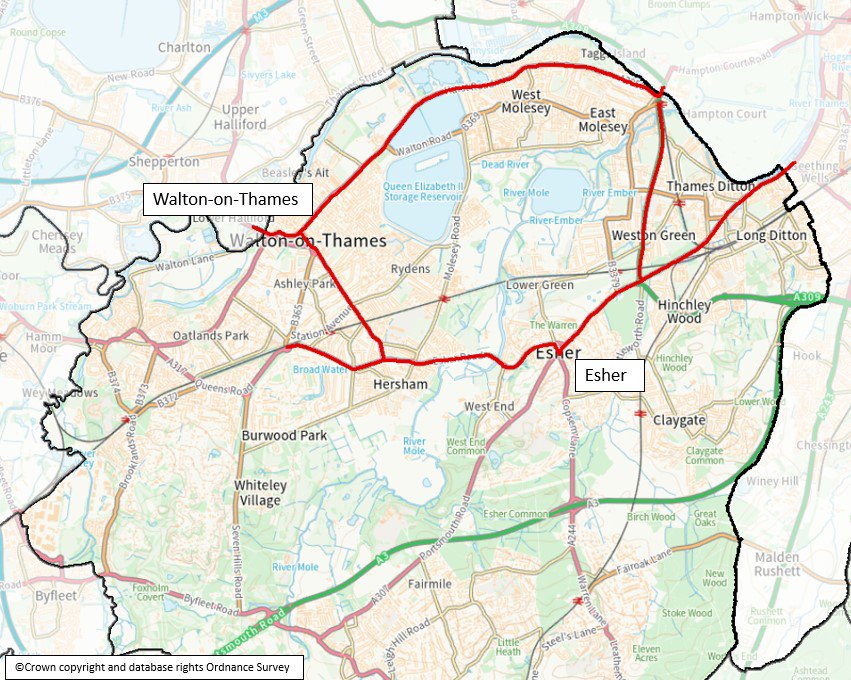
The below map image shows the extent of the five cycling routes that have been prioritised in the Elmbridge LCWIP (Esther Road, Queensway and Queens Road, Hersham Road, Walton to Molesey Link, Portsmouth Road North and Hampton Court Way).
Phase 2 and 3 cycling routes
- Weybridge Road. This corridor provides a strategic link between Weybridge town centre and Runnymede Borough over the River Wey and provides connectivity to the A317 cycle corridor identified as part of the Runnymede LCWIP. Approximate length: 0.4 kilometres.
- Thames Path. Provides an off-road route along the north side of Elmbridge. It is a popular leisure route for walking and cycling and provides value for utility trips due to its proximity to several town centres, several schools, and Hampton Court Station. Approximate length: 11.2 kilometres.
- Oatlands Drive. This route connects Weybridge and Walton town centres, as well as providing access to a local commercial area along Oatlands Drive. Approximate length: 2.6 kilometres.
- B374 Weybridge. This route provides connectivity between Weybridge town centre, Weybridge Station, Brooklands College, and the Brooklands employment hub. Approximate length:5.7 kilometres.
- Ember Lane and Esher Road. This route provides a link between the A307 corridor and East Molesey and Hampton Court, allowing direct access to railway stations and schools. Approximate length: 3.6 kilometres.
- Walton to Weybridge via Queens Place. Forms part of strategic east/west corridor across the borough and provides a link between Weybridge and Walton stations and multiple schools. Approximate length: 4.4 kilometres.
- Queens Road. The west segment of the strategic east/west corridor - linking the Walton to Weybridge corridor to Weybridge town centre, and access to the Queens Road commercial area. Approximate length: 0.9 kilometres.
- Waterside Drive access to Thames Path. Short link between the Thames Path and Terrace Road corridors, providing access to the leisure complex, nearby schools and developments. Approximate length: 0.7 kilometres.
- Byfleet Road to Cobham. This strategic route across the south of the borough links Cobham town centre to Brooklands and Byfleet, and onward towards Woking to link with the Woking LCWIP proposals. Approximate length: 3.9 kilometres.
- Portsmouth Road South. This strategic north/south corridor links Cobham and Esher town centres, supporting significant future development. Approximate length: 5.6 kilometres.
- Rydens Road and Station Avenue. This network link seeks to provide access to Walton Station and several schools, running between Molesey Road and Ashley Road (B365). Approximate length: 2.9 kilometres.
- Seven Hills Road. This network link improves north/south connectivity between two population centres, linking the Weybridge, Waltham and Hersham area with Cobham. Approximate length: 3.3 kilometres.
- Copsem Lane and Warren Lane. Strategic north/south network link, connecting Esher and Oxshott, and onwards to Leatherhead and Mole Valley. The corridor also provides access to Oxshott Station, nearby schools and proposed development. Approximate length: 6.1 kilometres.
Walking network
Phase 1 walking zones
Cobham town centre
This walking zone is focused on Cobham's High Street, along the A245. Measures include provision of several new crossing points, raised tables at side road crossings, and reducing the car-dominated feel of the high street by widening footways, providing more crossing opportunities, and reducing the speed limit to 20mph throughout the town centre.
East Molesey (Walton Road)
This walking zone extends along Walton Road's shopping area, and benefits nearby schools. Proposals include implementation of a 20mph limit between Langton Road and Bridge Road, installing zebra crossings across Walton Road near Manor Road, near Kent Road, adjacent to Candle Mews, and a signalised crossing at the west end of the main shopping area, between Dennis Road and Seymour Road. Opportunities for improving the pedestrian and cycling environment around Saint Lawrence and Saint Albans Schools will also be investigated.
Hersham (Molesey Road)
This walking zone focuses on the shopping area in Hersham Village (Molesey Road) and considers linkages to nearby railway stations and schools. Proposed interventions include introduction of a new 20mph speed limit on Molesey Road south of A244, improving crossing facilities at the A244 Roundabout and Molesey Road, and considering a "School Streets" initiative on Hersham Road at Bell Primary School.
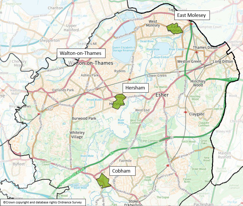
The below map image shows the extent of the three core walking zones that have been prioritised in the Elmbridge LCWIP (Cobham, East Molesey and Hersham).
Phase 2 and 3 walking routes and zones
- Esher (A307 High Street). This zone is focused around Esher's town centre and aims to reduce the car-dominated feel of the High Street and surrounding area.
- Hampton Court (Bridge Road). This zone is focused around the shopping area along Bridge Road and includes linkages to Hampton Court and railway station.
- Thames Ditton (High Street). This zone is focused around Thames Ditton's High Street and improves links to Thames Ditton railway station.
- Walton on Thames town centre. This zone is focused around the main shopping, dining, and commercial hub of Walton-on-Thames' town centre, including High Street, New Zealand Avenue, and the A3050.
- Walton on Thames A3050 corridor. This zone extends between Thames Mead and Cambridge Road, focusing around the local shopping parade on Terrace Road (A3050).
- Weybridge Queens Road corridor. This zone extends from Manby Lodge Infant School to the south of the railway crossing and is focussed around the shopping parade on Queens Road (A317) between York Road and the railway.
- Weybridge town centre. This zone covers Weybridge town centre, including High Street, Baker Street, and Heath Road. This zone will be complimentary to Weybridge town centre renewal project proposals.
- Claygate. This zone covers the shopping area in central Claygate, focused around High Street and Church Road.
- Claygate Station. This zone is focused improving the pedestrian environment on The Parade and access to Claygate railway station.
- Cobham and Stoke d'Abernon. This zone focuses on the amenities located on Station Road and improving the pedestrian environment at Cobham and Stoke d'Abernon Station.
- Hinchley Wood. This zone is focused around improving the pedestrian environment near Hinchley Wood railway station.
- Oatlands. This zone extends between St Mary's Road and Vale Road, focusing on the shopping parade along Oatlands Drive (A3050).
- Oxshott. This zone is focused around Oxshott village centre and aims to improve the pedestrian environment in the area on High Street (A244) between Steel's Lane and Oakshade Road.
Next steps
The Elmbridge LCWIP report will be used to support the case for further stages of design, assessment, and stakeholder engagement, and to secure funding to progress improvements for the routes identified by the report. Because the LCWIP is intended to facilitate a long-term approach to developing active travel proposals, over a period of approximately 10 years, all the corridors identified within the active travel network maps are recommended for further consideration at an appropriate time.
The next stage of implementing the Elmbridge LCWIP will be to further develop the design concepts for the Phase 1 cycling and walking routes into a feasibility level of design and assessment. This will include full public consultation, allowing residents and other local stakeholders to have their say on the individual scheme proposals.
The LCWIP will be reviewed and updated periodically, particularly in response to significant changes in local circumstances, such as the publication of new policies or strategies.
If you wish to view the full Elmbridge LCWIP report, please email surreytransportplan@surreycc.gov.uk requesting a copy.
