 Surrey History Centre holds parliamentary enclosure maps and awards for parishes in the old county of Surrey, including those parts which are now London boroughs. Enclosure maps and awards for Spelthorne (which was formerly in Middlesex) are held at The London Archives.
A handlist is available at Surrey History Centre showing which enclosure maps we hold, arranged by parish, and giving areas included, dates and sizes of maps, and details of related material. There are also guide maps showing the boundaries of the enclosure maps we hold.
Surrey History Centre also holds some related material such as enclosure commissioners' minutes and account books.
Tip: When searching databases try both the spellings enclosure and inclosure. (Use *nclosure on our Surrey History Centre catalogue).
Early enclosure
Enclosure took place when wealthy landowners enclosed areas of common land for their exclusive use or enclosed areas of arable land for pasture; or when groups of tenants agreed to consolidate their landholdings into larger units.
Even in medieval villages where the fields were farmed communally there would have been some enclosures, for example to keep young animals in a confined area. As time went on many people were permitted to enclose areas of waste for cultivation.
There are few records of early enclosures, although evidence of what took place can sometimes be found amongst estate and manorial records, and some estate maps show fields before or after enclosure. It was only from the mid-16th century that many enclosures were enrolled in the courts of equity.
Records of non-parliamentary enclosure in Surrey include a deed relating to the enclosure from the waste of Claygate Manor, Ash in 1707 (reference 212/4/16), and a plan of Sheepwalk at Abinger which shows common land and enclosures on the boundaries of Abinger, Effingham and East Horsley (reference 6330/4/2/2) and which has been dated between 1700 and 1750.
The Enclosure Maps and Awards were produced as a result of Parliamentary Enclosure which became common from about 1750.
Parliamentary enclosure
21% of England was enclosed by Act of Parliament. There were over 5000 Acts dealing with almost 7 million acres of land. About 2/3 of the land enclosed had been arable and 1/3 common or waste.
Enclosures by private Act of Parliament
Enclosure of arable land, waste and common by private Act of Parliament became common from 1750. There were soon so many Acts that the first Public General Act was passed in 1801 to try to simplify the procedure and save parliamentary time.
To start the process a bill was submitted to parliament. Many bills were opposed, either by people wishing to revise clauses, perhaps to their own advantage, or by people opposed to the enclosure in any form. The most serious opposition took the form of a counter-petition. Sometimes a new bill had to be presented and enclosure could be delayed for many years.
Between 1730 and 1839, for places in Surrey, 101 bills were submitted to Parliament but only 50 Acts were passed. This was a high percentage failure rate compared to other English counties. There was plenty of opposition in Surrey, as evidenced by the 25 counter-petitions recorded.
One Surrey example of enclosure by private Act of Parliament is the Act to enclose land at Egham, 1814 (reference 2225/10/1), and the resulting award and map, 1817 (reference QS6/4/25). Material related to this enclosure includes a book of reference to old enclosures and allotments (reference 185/16/2) and related papers, 1817 (reference 373/1).
Enclosures under the public General Enclosure Acts of 1836, 1840 and 1845
The General Enclosure Acts of 1836 and 1840 made it possible for landowners to enclose land without reference to parliament as long as a majority of them (in value and number) agreed to do so. The General Enclosure Act of 1845 and later amendments attempted to provide better protection for the interests of small proprietors and the public.
Some places were enclosed over a period of time, for example, in Surrey, Chobham Common Field was enclosed in 1842 under the 1836 Act (reference QS6/4/40), whilst other land in the Manor of Chobham was enclosed in 1855 under later Acts (reference QS6/4/52).
Enclosure Commissioners
Initially each Act named the Commissioners who would administer the process. The General Enclosure Act 1845 appointed permanent salaried Enclosure Commissioners, with the power to issue Enclosure Awards without submitting them to parliament for approval. They had Assistant Enclosure Commissioners and Surveyors to help them with their work.
The Commissioners allocated plots which they considered to be a fair equivalent "in full and perfect satisfaction" of pre-existing open lands and common rights. Their final decisions were recorded in the Enclosure Award. A surveyor prepared the Enclosure Map which was appended to the award.
Enclosure awards
Enclosure awards are formal legal documents recording the decisions of the enclosure commissioners.
The award begins with a customary greeting and then recites the Act under which it is executed followed by the proceedings of the commissioners.
Then follow details of the allotments made. First those for highways and public use, and then those to individuals. The preamble contains:
- Public roads, turnpike roads and private roads (with widths).
- Public bridleways (with widths).
- Public footpaths and private footpaths (with widths).
- Public drains and liability for their repair.
- Allotment of gravel pits for road repairs.
- Area of land for public exercise and recreation.
- Allotment to the Lord of Manor for his 'right of soil' on the common.
- Allotment to the Rector for his glebe land.
- Ancient enclosures.
- Arrangements for the maintenance of hedges, fences and watercourses.
- Value of tithes commuted for corn rent.
Then there is usually a schedule listing all the plots as numbered on the appended Enclosure Map, giving:
- Name of person
- Number on the Enclosure Map
- Area
- Type of tenure: copyhold or freehold
- Rent-charge.
The Commissioner ordered sufficient fencing to be put in place, and the award finishes with the date and a record of signing and sealing. Then there was a proclamation in the parish church.
The Acts specified where a copy of the award should be enrolled. This was usually with the local Clerk of the Peace, and for Surrey these copies are now at Surrey History Centre (reference QS6/4/-). Other copies could be made for major landowners, often the parish, and many of these have been deposited at Surrey History Centre. The records of the Enclosure Commissioners after 1845 are at the The National Archives (reference maf 1).
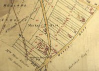
Enclosure maps
Enclosure maps are large-scale plans which must be used in conjunction with the Enclosure Awards for detailed study.
There is usually only one copy of each enclosure map, and this is appended to a copy of the enclosure award. Sometimes there isn't a map.
Enclosure maps show stopped up roads, old enclosures, boundaries, public roads and footways, land drainage and allotments of land for public purposes such as parish gravel pits.
Enclosure Maps vary greatly in size depending upon the area of common or waste to be enclosed. For example the Lingfield enclosure maps measure 13 x 23 inches each (reference QS6/4/26), whilst the Frensham enclosure map measures 154 x 80 inches (reference P57/8/1).
Further reading about enclosure
- Kain, R.J.P., Chapman, J. and Oliver, R.R. The enclosure maps of England and Wales 1595 to 1918: a cartographic analysis and electronic catalogue. Cambridge University Press, 2004. See also the Searchable electronic catalogue of enclosure maps of England and Wales.
- Tate, W.E. The English village community and the enclosure movements. Gollancz, 1967. Introduction.
- Tate, W.E. A Domesday of English Enclosure Acts and Awards. University of Reading, 1978. Comprehensive guide to the location and date of English parliamentary enclosure maps and awards.
- Turner, M. and Wray, T. A survey of sources for parliamentary enclosure: the House of Commons' Journal and Commissioners' working papers in Archives, volume XIX (19), number 85, April 1991, pages 257 to 288. Table showing number of bills, counter-petitions and acts for each English county. List, arranged by county, of locations of commissioners' minute books, account books and other associated documents.
- Chapman, J. and Seeliger, S. Enclosures by non-parliamentary means: some comments on the records in Archives, volume XXII (22), number 95, October 1996, pages 100 to 106. Discussion of the extent to which formal and informal ways were used to enclose land in the 18th and 19th centuries as a less costly alternative to Act of Parliament.