About the project
The Guildford to Godalming Greenway (GGG) is a scheme aiming to deliver high-quality active travel infrastructure between Guildford, Godalming and the communities/areas in between.
The full scheme would result in over 7km of improved infrastructure which aims to overcome existing barriers to walking, wheeling and cycling.
Key benefits of the scheme include:
- Improved safety and accessibility for users;
- Improved journey quality for those that walk, wheel or cycle;
- Health and wellbeing benefits for users due to increases in physical activity; and
- Improved accessibility to green spaces in the local area.
A feasibility study funded by National Highways Designated Funds was first completed to develop the scheme proposals. A public consultation was then carried out in late 2021 which demonstrated strong support for the proposals.
Detailed design work, also funded by National Highways Designated Funds, has then followed the public consultation. The detailed design work has taken into account feedback to the public consultation.
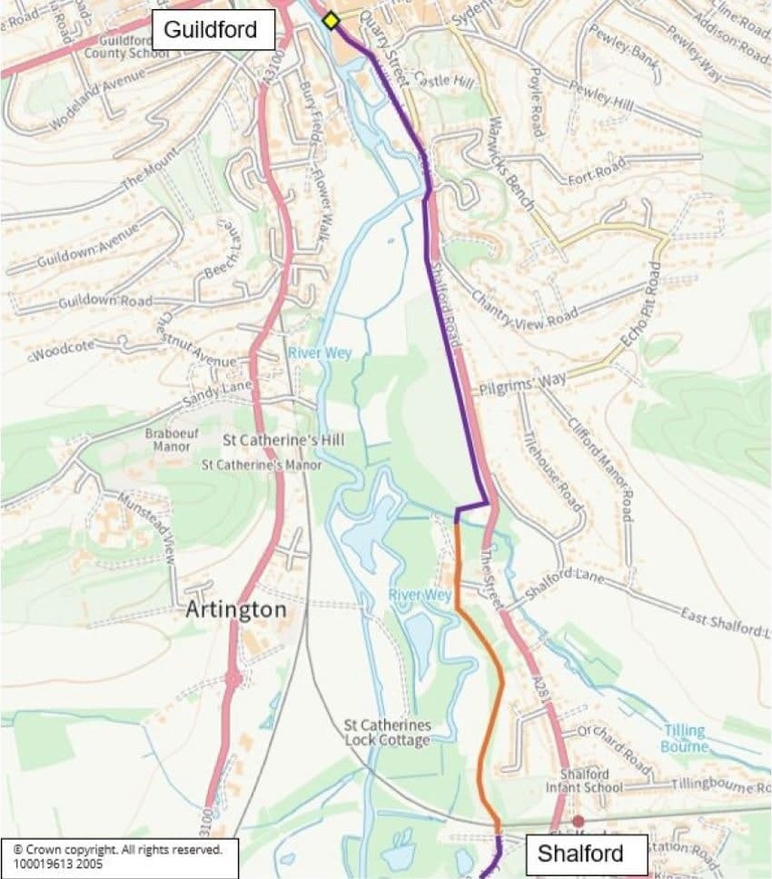
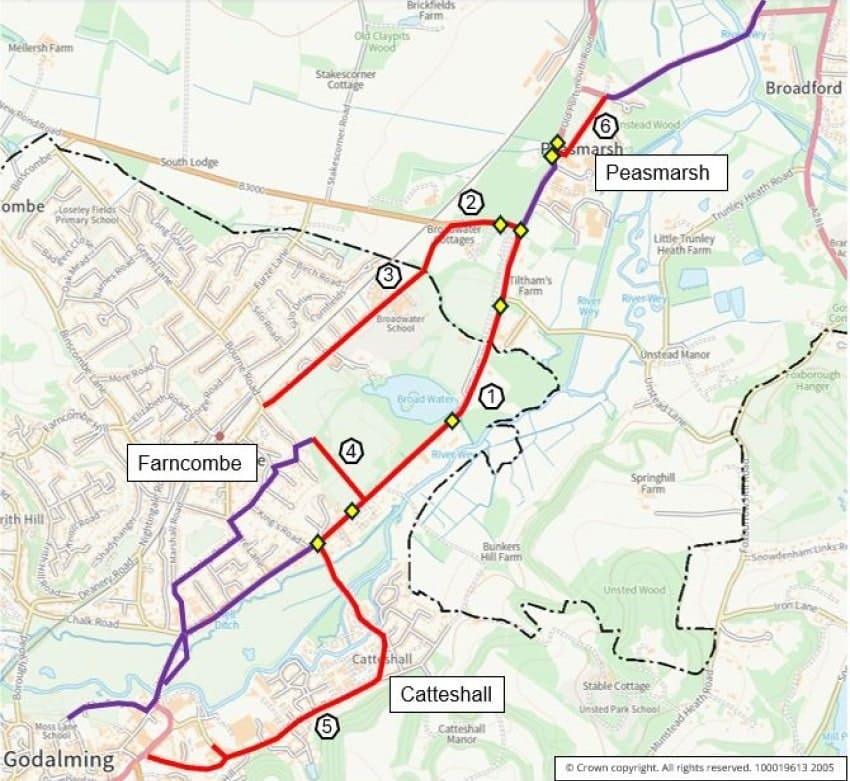
The proposed route of the Greenway is shown on the maps further down this page.
Phase 1 construction
In 2023 an application for construction funding was submitted to Active Travel England to construct a first phase of the scheme. The application for construction funding was successful. Phase 1 will deliver benefits as a standalone scheme, as well as part of the full scheme that would come in a later phase(s), subject to further construction funding being awarded.
Construction commenced on the 13 January 2025 with an initial period of works focused on the A3100 between B3000 New Pond Road and Guildford Rugby Club. The works consisted of widening the western footway for a shared footway/cycleway as well as the installation of a signal crossing near Tilthams Corner Road. This period of work has ended (ended on 16 March 2025) and further works are being planned to commence later in the year. This will include further works on the A3100 to provide the full scheme proposed between New Pond Road and Catteshall Road. Construction dates will be published as soon as they are confirmed and further communications will be released to local residents and stakeholders.
Phase 1 scope
Phase 1 includes the scheme elements listed below, also identified on the maps.
- Widening and extension of the substandard shared footway/cycleway along western side of the A3100 between New Pond Road and Catteshall Road. The southernmost section leading to Catteshall Road includes segregated cycle tracks on both sides of the A3100. Along this section four signalised crossings are proposed as well as six road tables (in side roads/accesses, not on the A3100). The Plan called "Plan – A3100 Design Plans (Summary)", available to view from the webpage below, summarises the design plans for this section.
A3100 Old Portsmouth Road, Guildford Road and Meadrow proposals
We recently consulted on the proposed new signalised crossings and road tables. Responses are being reviewed and will inform the decisions on how we will proceed.
- Improvements to the substandard shared footway/cycleway along New Pond Road between the A3100 and Summers Road.
- Improvements on Summers Road, which provides a direct route to Broadwater School, including footway improvements for pedestrians and a signed on-carriageway cycle route. A 20mph speed limit is proposed.
- A new bound path for pedestrians and cyclists through Broadwater Park to connect Farncombe with the main route along the A3100.
- A signed on-carriageway cycle route along Catteshall Road and Catteshall Lane. To also include footway improvements for pedestrians and a proposed 20mph speed limit.
- A signed on-carriageway cycle route along Oakdene Road. A 20mph speed limit is proposed.
- Crossing improvements including new signalised crossings on the A3100 and New Pond Road.
Map 1 below shows the northern section of the Guildford to Godalming Greenway route. Red indicates a section in phase 1. Purple indicates a section in later phases. Orange indicates a section in the Dagley Lane scheme. Yellow diamonds indicate proposed new or improved signalised crossings for pedestrians and/or cyclists.

Map 2 below shows the southern section of the Guildford to Godalming Greenway route. Red indicates a section in phase 1. Purple indicates a section in later phases. Orange indicates a section in the Dagley Lane scheme. Yellow diamonds indicate new or improve signalised crossings for pedestrians and/or cyclists.

Dagley Lane
The Greenway's route includes an off-road section along Dagley Lane, north of Shalford. This is an existing signed walking and cycling route, however, it lacks a bound surface and during the wetter months of the year in particular, the route can be impassable and is not inclusive to most users.
Works to install a bound path have been completed for a section immediately north of Dagley Lane bridge (over the railway). It is planned to extend this further to Shalford Thames Water. Constructing this would include removing the steps that currently pose an accessibility issue, creating a slope instead. Surrey County Council is working with Thames Water to get the plans agreed and the works scheduled for this section. Dates for the works will be published when scheduled. The extent of the full Dagley Lane path works is shown on the Greenway maps.

