
The Greensand Way offers an outstanding hilly walking experience for all ages and abilities, whether you're a long-distance walker wanting to challenge yourself to walk the whole 108 mile route through Surrey and Kent, or fancy a shorter linear section through some of our most beautiful countryside.
 Page contents
- The 10 Parts of the route
- Map of the whole route
- More about the Greensand Way
- Signposts and signing
- The Countryside Code
The 10 Parts of the route
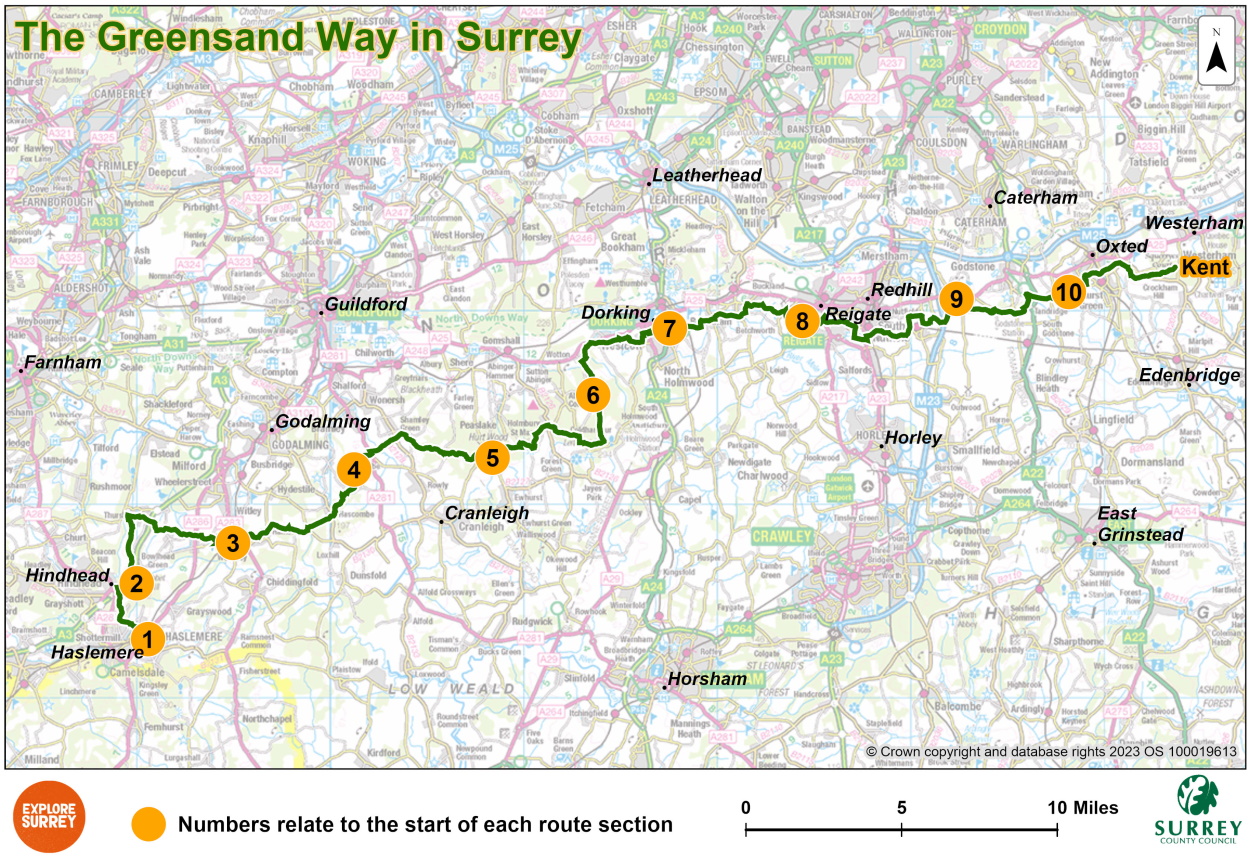
The following pages provide details of each part of the route of The Greensand Way in Surrey, with a map showing the stages of the route and what you can see. The Surrey section of the route is just over 57 miles long, with mileage and approximate timings of each part given below.
- Part 1: Haslemere to Gibbet Hill, Hindhead, 3.5 miles, allow 1.5 hours
- Part 2: Gibbet Hill, Hindhead to Witley Station, 6.5 miles, allow 3.5 hours
- Part 3: Witley Station to Gatestreet Farm, Grafham, 6 miles, allow 3 hours
- Part 4: Gatestreet Farm, Grafham to Pitch Hill, Ewhurst, 6 miles, allow 3 hours
- Part 5: Pitch Hill, Ewhurst to Broadmoor, Wotton, 7 miles, allow 3.5 hours
- Part 6: Broadmoor, Wotton to Deepdene, Dorking, 6 miles, allow 3 hours
- Part 7: Deepdene, Dorking to Reigate Priory Park, 6 miles, allow 3 hours
- Part 8: Reigate Priory Park to Castle Hill, Bletchingley, 7 miles, allow 3.5 hours
- Part 9: Castle Hill, Bletchingley to Oxted Place, 5 miles, allow 2.5 hours
- Part 10: Oxted Place to county boundary, beyond Limpsfield Chart, 5 miles, allow 2.5 hours
You are advised to use the above maps in conjunction with an OS Explorer Series map – numbers 133, 145, 146, 147 cover the entire Surrey section and provide more detail. For a key to map symbols, see the Ordnance Survey website.
Most parts of the walk follow legally defined as 'rights of way'. If you experience a problem on a public right of way, please use our fault reporting form to notify us or call 03456 009 009 for our contact centre.
Where public transport is available, information is given in the walk directions. You can find more detailed transport information including bus and train timetables, on our Buses and other Transport page.
Map of the whole route
The route starts in Haslemere, passes the Devil's Punchbowl at Hindhead, goes over the Surrey hills of Hascombe, Pitch, Holmbury and Leith Hill, before descending north to Dorking, Reigate and into Kent just beyond Limpsfield. Select the map of the route below to open a larger version in a new window, that can be printed, if necessary, using your browser print tool with landscape selected. Alternatively, you can save the image to your mobile device, for reference on your walk.
More about the Greensand Way
The Greensand Way follows the ridge of greensand rock across Surrey and Kent, starting in Haslemere and finishing in Hamstreet, just short of the Kentish coast. This sandstone rock, containing the green coloured mineral glauconite (also known as 'green sand'), gives the route its distinctive name.
The entire route was conceived by the Ramblers during the 1980s. We work with and are grateful for the support of many volunteers, including Surrey Ramblers' volunteer groups on route checking, signage reporting and repairs on this and other Surrey public paths.
For further general information on the route, visit the Long Distance Walkers' Association website and visit Explore Kent for continuation of the route into Kent.
Highlights
- Walk through the Surrey Hills National Landscape and the Kent Downs - two Areas of Outstanding Natural Beauty
- Quiet, tranquil but hilly sections on this route
- Beautiful views across the Weald to the south and north towards the North Downs
- Many villages along the route with local pubs and village shops
- Excellent links to railway stations and main roads.
Signposts and signing of the route through Surrey
In Surrey, the Greensand Way covers 57 miles and has been split into ten sections of between 3 and 8 miles each. In the countryside the route is signposted by circular discs with a sketch of Leith Hill Tower and GW around it in the centre of the directional arrow. These are yellow on black for a public footpath, blue on white for a public bridleway and red on white for public byways. You can walk the route in either direction.
Where the Greensand Way crosses or leaves a metalled road there are small brown and white Greensand Way signs attached to the wooden public footpath, bridleway or byway signposts.
For details of the route through Kent, visit: Explore Kent website.
The Countryside Code
![]() The Countryside Code (GOV.UK) is national statutory guidance that gives general guidelines for countryside usage that everyone should be aware of. Find out more on our Countryside advice page and watch videos from our Countryside Champions. Follow the simple steps below to protect the countryside and enjoy your great day out:
The Countryside Code (GOV.UK) is national statutory guidance that gives general guidelines for countryside usage that everyone should be aware of. Find out more on our Countryside advice page and watch videos from our Countryside Champions. Follow the simple steps below to protect the countryside and enjoy your great day out:
- Respect other people
- Protect the natural environment
- Enjoy the outdoors.